SAN FRANCISCO - Swift Navigation, the San Francisco-based tech firm building centimeter-accurate GPS technology to power a world of autonomous vehicles, announced that it has moved its headquarters to 650 Townsend Street, Suite 410, San Francisco, CA 94103 (located...
Space Flight Laboratory Highlights 20 Years of Microspace Achievements at U.S. and Canadian Small Satellite Symposia in February
TORONTO, Ontario, Canada – Space Flight Laboratory (SFL), a provider of complete microspace missions, will celebrate 20 years in business by showcasing its nanosatellite and microsatellite successes next month at the 2018 SmallSat Symposium in Silicon Valley and...
Boundless Launches Massively Scalable Geospatial Server for the Enterprise
St. Louis, MO – Boundless, the leader in open GIS, today introduced Boundless Server Enterprise™, the first cloud-native geospatial web server designed to take advantage of the cloud’s ability to quickly and easily scale up and out. Today, more location...
In-Orbit Servicing Market Opportunity Exceeds $3 Billion
CAMBRIDGE, Mass. - NSR’s industry-first In-Orbit Servicing Markets (IoSM) report, released today, finds the nascent in-orbit servicing market poised for growth, and forecasts a total market of over $3B in the next 10 years. Life extension services drive most of this...
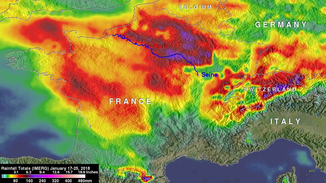
France's Flooding Rains Examined by NASA
Eastern France has experienced unusually heavy rainfall in early 2018, and NASA satellite data has helped determine where the largest rainfall occurred.
GfK Launches RegioGraph Online
Bruchsal, Germany – GfK has developed a new, additional version of its geomarketing solution, RegioGraph. “RegioGraph Online†allows users simultaneous access via a web browser to information about the surroundings of a prospective location. These findings can...
Solving City Management Problems with UAV Data and Geoscan Software
Solving urban problems requires timely information about every aspect of the city functioning. Today using UAV's is a great way for local governments to get precise data as 3D models, orthophotos and digital elevation models. However, collecting data is just a first...
2018 URISA Exemplary Systems in Government Awards Process Opens
URISA is pleased to announce the Exemplary Systems in Government (ESIG) Awards process for 2018. Since 1980, URISA's ESIG Awards have recognized extraordinary achievements in the use of geospatial information technology that have improved the delivery and quality of...
HERE to Acquire Global Indoor Maps Provider Micello
Santa Clara, CA - HERE Technologies today announced that it has signed a definitive agreement to acquire Micello, a privately held software company based in California that operates a platform for creating, editing and publishing indoor maps. The planned acquisition...
Topcon Announces New Manual Total Station with Advanced Performance and Accuracy
LIVERMORE, Calif., U.S./ CAPELLE A/D IJSSEL, the Netherlands – Topcon Positioning Group announces the new GM-100 total station designed to provide a powerful EDM along with advanced integrated communications technology in a manual package.  “It delivers the...
