The European Space Agency's three-satellite Swarm constellation was lofted into a near-polar orbit on Nov. 22, 2013, from which it will monitor Earth's magnetic field for the next four years.
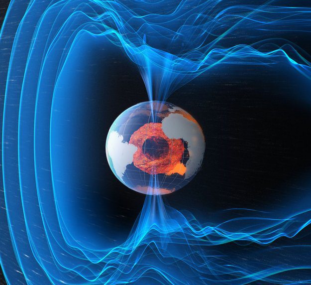
The European Space Agency's three-satellite Swarm constellation was lofted into a near-polar orbit on Nov. 22, 2013, from which it will monitor Earth's magnetic field for the next four years.
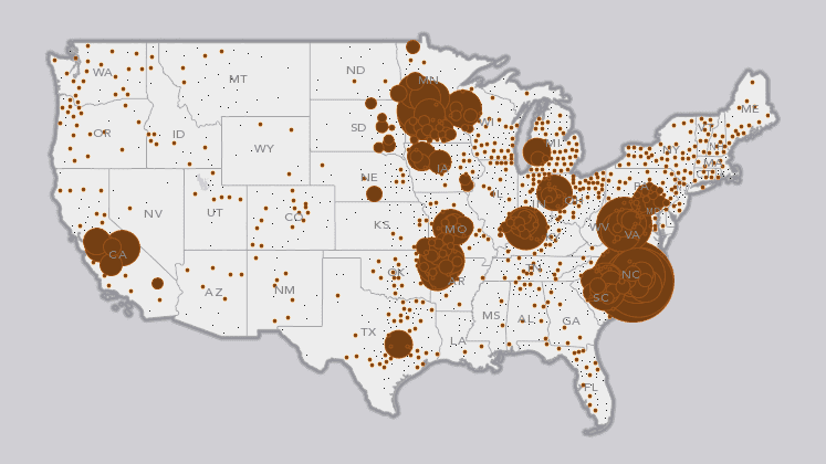
Compiled from U.S. Department of Agriculture Census of Agriculture data, here's a geospatial perspective on where your holiday turkey and three popular side dishes likely originated.

Lewis Whyld used an unmanned aircraft system to show the scale of Typhoon Haiyan damage and, according to Whyld, discover two bodies later recovered by the authorities.
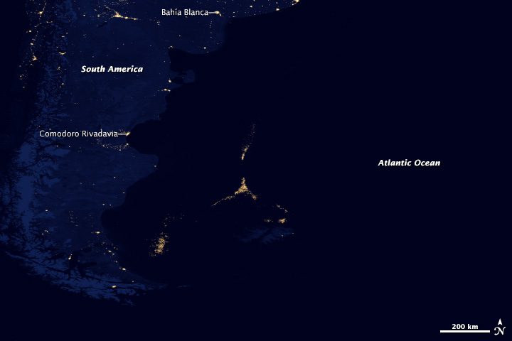
When NASA and NOAA released their newest map of Earth at night, a new city of light appeared in the middle of the South Atlantic Ocean about 300 miles off the coast of Argentina.
Berlin, Germany, Nov. 20, 2013—BlackBridge’s RapidEye products are an active part of the Sentinel-2 project from the European Space Agency (ESA). The RapidEye data, provided free of charge, simulates the Sentinel-2 frequency and will support further development of...
ROME, Nov. 20, 2013—International NGOs and the UN will bring aid in the field using disaster maps issued by the the European Commission's Copernicus Emergency Management Service soon after Typhoon Haiyan violently struck the Philippines on the 8th of November. The...
Bethesda, Md., Nov. 19, 2013—Bon A. Dewitt, Rongxing Li, Richard A. Pearsall, Karen L. Schuckman and Douglas A. Stow have been named the 2014 ASPRS Fellow Award winners. The ASPRS designation of Fellow is conferred on active Society members who have performed...
Hallowell, Maine, Nov. 19, 2013—Blue Marble Geographics (www.bluemarblegeo.com) will be exhibiting at the GeoDATA London Mapping Showcase at the ILEC Conference Centre on Thursday, November 28, 2013.  Blue Marble will be demonstrating low cost GIS using Global...
RICHMOND HILL, Ontario, Canada, Nov. 21, 2013—PCI Geomatics, a world-leading developer of geoimaging software and systems, announced today that it presented an award to Carleton University student Rachel Plewes in recognition of her academic achievements. The award...
Nov. 21, 2013—A recently launched greenhouse gas emissions measurement service from Astrium, the world’s second largest space company, has been included in the Climate and Energy Action Hub, an interactive platform to encourage companies to collectively provide...
