MINNEAPOLISÂ -Â A reference database covering all of Africa is available for the first time with the release of the African Development Data Explorer (ADDaX), from East View. ADDaX is the first economic product to cover all 54 African countries, and the only one to...
1Spatial Underpins Web-based Mapping & Asset Management Solution at Network Rail
Cambridge, UK: (www.1spatial.com) 1Spatial is the global spatial software firm which manages the world’s largest spatial data. The company was chosen by Network Rail to provide its geospatial technology, which underpins an innovative web-based mapping and asset...
Apps, Paths and Drones: Geovation Announces its Next Generation of Programme Members
This summer, Ordnance Survey invited developers, entrepreneurs and innovators to apply to its Geovation Programme for funding and resources. Flock: a deep-tech AI company performing Big Data-driven risk analysis for drone flights to create intelligently priced...
Trimble to Acquire Building Data to Expand Constructible Model and BIM Content Offering for Construction
LAS VEGAS -Â Trimble (NASDAQ: TRMB) announced today it has entered into a definitive agreement to acquire privately-held Building Data based in Rocklin, Calif. Building Data's managed content and software solutions enable Mechanical, Electrical and Plumbing (MEP)...
Drone USA, Inc. Signs Letter of Intent to Acquire Accredited Aerospace Manufacturer and Distributor
NEW YORK -- Drone USA, Inc. (OTC:DRUS) (“Drone USA†or the “Companyâ€), a developer and manufacturer of low altitude Unmanned Aerial Vehicles (“UAVâ€) and related technologies, today announced that it has signed a Letter of Intent (“LOIâ€) to acquire a...
Getmapping Launches GeoXphere at INTERGEO 2016
Leading aerial survey and GIS solutions provider Getmapping used the INTERGEO Conference and Exhibition to launch a new joint venture – GeoXphere - developed in partnership with WaldoAir, the leading provider of low-cost aerial imaging solutions. GeoXphere brings...
IMAGINiT Technologies Acquires Autodesk Business from Eagle Point Software
OWINGS MILLS, MD — Rand Worldwide (OTCBB: RWWI), a global leader in providing technology solutions to organizations with engineering design and information technology requirements, announces that its IMAGINiT Technologies division has acquired the Autodesk...
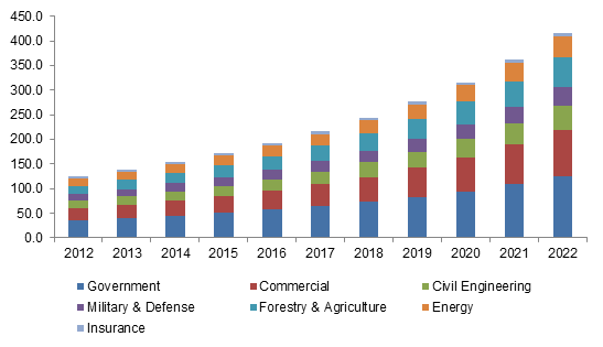
Aerial Imaging Market Forecast to Reach $2.64 Billion by 2022
According to a new research report by Global Market Insights, the aerial imaging market is estimated to grow to $2.64 billion by 2022.
Britain on Foot Campaign Pledges to #GetOutside
From Thursday 17 November, visitors to the Britain on Foot website (www.britainonfoot.co.uk) will be re-directed to a dedicated landing page on the OS site. The page is part of an all new #GetOutside section that hosts an extensive directory of routes and maps, skills...
Esri Releases Baseline Map to Support Ocean Ecosystem Research Efforts
Esri has released a baseline set of three-dimensional mapped Ecological Marine Units for researchers to examine the ocean’s resources and detect ecological marine changes. The company said the Group on Earth Observations, a consortium of more than 100 nations...
