Teledyne Optech is pleased to announce that Mr. Martin Flood has joined the company as Director of Business Development. In this global role, Mr. Flood will concentrate on expanding the reach of the Teledyne Optech product portfolio to new markets, and will identify...
Leica Geosystems Combines New UAV Technology with DJI Aerial Platform to Complete Flight Missions in Less Time
(Heerbrugg, Switzerland) – Leica Geosystems, part of Hexagon, industry leader in measurement technology, announced today the new Leica Aibot, the latest Unmanned Aerial Vehicle (UAV) system based on DJI’s aerial platform, the M600 Pro, to rapidly and autonomously...
FLIR Receives Red Dot: Best of the Best 2018 Award for FLIR T500-Series
WILSONVILLE, Ore., – FLIR Systems, Inc. (NASDAQ: FLIR) today announced the selection of the FLIR T500-Series as a “Red Dot: Best of the Best†winner for 2018. The “Red Dot: Best of the Best†is awarded for groundbreaking product design and is given as the...
GEO Jobe Announces Release of Admin Tools for ArcGIS Online V 1.2 in the ArcGIS Marketplace
NASHVILLE, Tenn. - GEO Jobe is pleased to announce an important update of the popular Admin Tools for ArcGIS Online (consistently a TOP app in the Esri ArcGIS Marketplace). The latest version of Admin Tools, 1.2, gives the ArcGIS Administrator even more functionality...
New Leica iCON Construction Total Stations Provide Efficient Layout Solution
(Heerbrugg, Switzerland) – Leica Geosystems, part of Hexagon, industry leader of measurement technology, announced today the new Leica iCON construction total stations, Leica iCR70 and Leica iCR80, the most productive one-person layout solution for building...
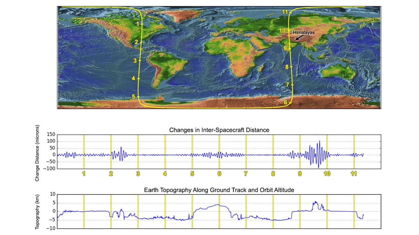
Recently Launched Twin Satellites Create ˜The Himalaya Plot'
Less than three weeks after launch, the Gravity Recovery and Climate Experiment Follow-On (GRACE-FO) mission has successfully completed its first mission phase and demonstrated the performance of the precise microwave ranging system that enables its unique measurements of how mass migrates around our planet.
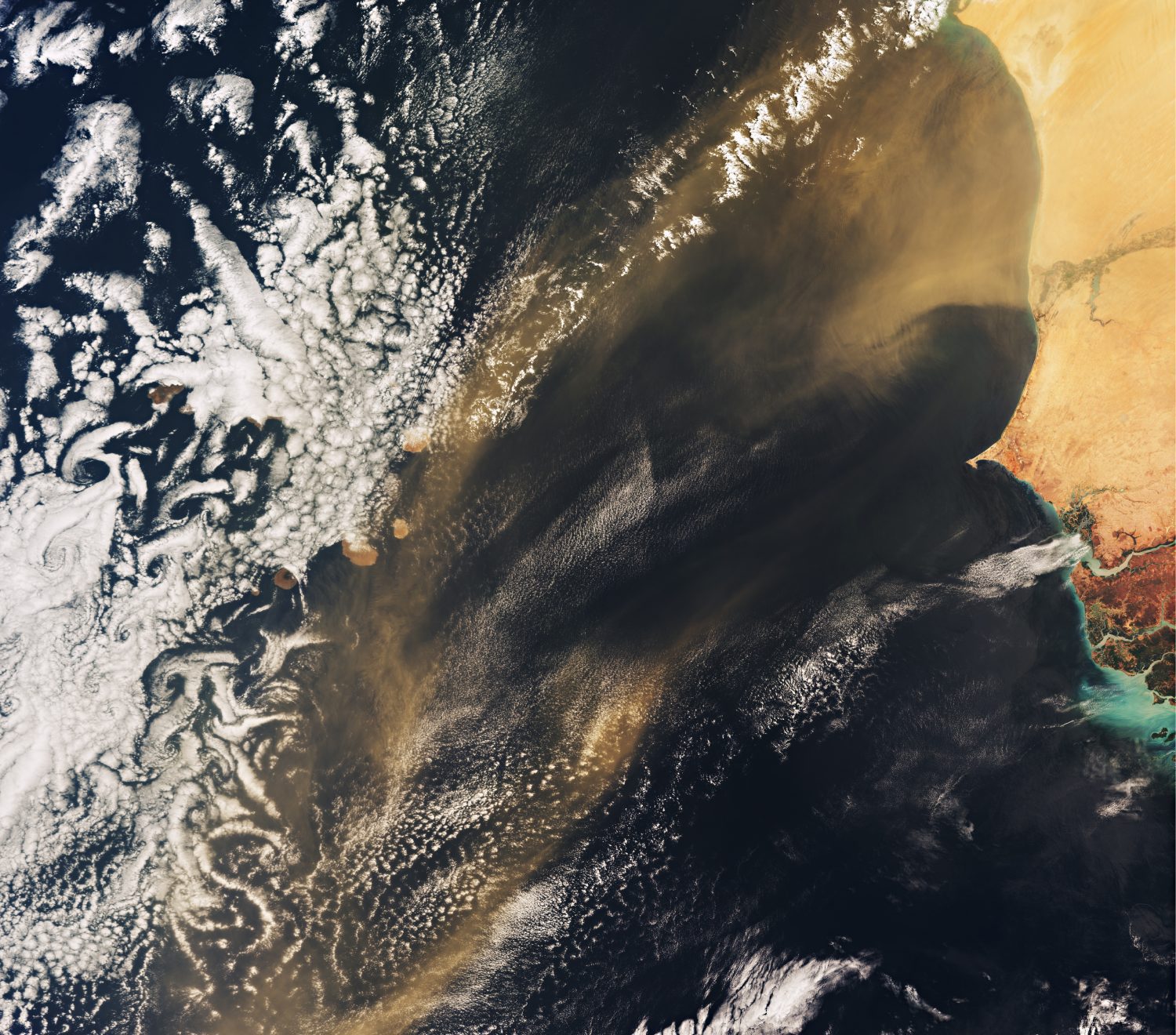
Nutrient Delivery from African Deserts to Cabo Verde
Celebrating World Oceans Day on June 8, 2018, the Copernicus Sentinel-3A satellite takes us over the Atlantic Ocean and the Republic of Cabo Verde.
Hexagon Launches Luciad V2018
NORCROSS, GA. – Hexagon’s Geospatial Division, a world leader in high performance geospatial solutions, is excited to announce full details of its Luciad V2018 release at HxGN LIVE 2018, taking place in Las Vegas, from June 12th – 15th, 2018. V2018 empowers...
ImageSat International and MAGNUS Launching a Smart New Way to Manage Natural Disasters
OR YEHUDA, Israel: ImageSat International N.V. ("ISI"), a global leader in end-to-end geospatial solutions, together with MAGNUS International Search & Rescue announces a new service - EMERGENCY AND DISASTER MANAGEMENT. The new service enables countries, cities...
Spaceflight to Launch Smallsats for Canon Electronics, BlackSky, and Others On Three Upcoming Rocket Lab Missions
SEATTLE - Spaceflight, the leading satellite rideshare and mission management provider, announced today it has partnered with Rocket Lab for three upcoming launches. The first Electron mission, scheduled for the end of 2018, will launch a BlackSky microsat along with...
