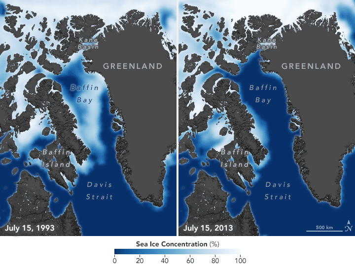
Sea ice concentrations have declined by 13 percent each decade since 1979 due to increasing global temperatures. Arctic regions have warmed twice as fast as the rest of the world, so seasonal sea ice is also forming later in the fall and breaking up earlier in the spring.
Lake George, Uganda
This Copernicus Sentinel-2 image takes us over Lake George, in western Uganda. In 1988, Lake George was designated as Uganda's first Ramsar site, given its importance as a center for biological diversity.
Phase One Industrial and AI-Survey GmbH Sign Partner Integrator Agreement
Enabling new opportunities in drone-based high-end aerial imaging  Copenhagen, Denmark and Altenkirchen, Germany – Phase One Industrial, a world-leading provider of medium format metric cameras and imaging solutions for aerial applications, today announced that...
Airbus, Hexagon sign on to Geo Connect Asia 2020
Airbus and Hexagon will be joining Geo Connect Asia 2020, South East Asia’s first-ever geospatial services and location intelligence event taking place on 18 and 19 March at Suntec Singapore. What organisers are calling an Asian event with a global audience, Geo...
URISA Announces 2020 Vanguard Cabinet of Young Professionals
URISA is pleased to announce the newest members of its Vanguard Cabinet. The Vanguard Cabinet (VC) is a URISA initiative (which debuted in 2011) to engage young GIS practitioners, increase their numbers in the organization, and better understand the concerns facing...
Cadcorp launches GIS data management tool
Cadcorp SIS ETL (Extract, Transform, Load) is a data management tool that manages and controls the flow of data between files, databases and servers. The applications of this tool include streamlining spatial data management and providing concurrent data for a cloud...
1Spatial announce the release of 1Integrate v2.6
Cambridge, UK- (www.1spatial.com) 1Spatial, the global geospatial software and solutions company, is pleased to announce the general release of 1Integrate v2.6. This release adds support for Google BigQuery, improved control when handling XYZM data, enhanced built-in...
Broadband Coverage Maps for Every Texas County Released, Your Feedback Needed to Improve Them
Austin, TX – Connected Nation Texas (CN Texas) just released its initial updated broadband (high-speed internet) coverage maps. These maps provide details on internet speeds and coverage for all 254 counties across the Lone Star State. “It’s been over five...
SimActive Announces New Drone Training Program for Mapping
Montreal, Canada, February 4th, 2020 – SimActive Inc., a world-leading developer of photogrammetry software, announces a new training program for drone mapping. The program’s goal is to provide educational material and resources on how to effectively process...
Geospatial Analytics Safety InSiteâ„¢ Delivers Powerful Safety Management Solution for Real Estate Portfolios
SCOTTSDALE, Ariz. - Geospatial Analytics®, a real estate software developer, announced a new release of Geospatial Analytics Safety InSite™. This powerful solution is an integral component of the Geospatial Analytics® industry-leading strategic real estate...