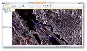
More individuals and organizations are harnessing the power of radar mapping data.
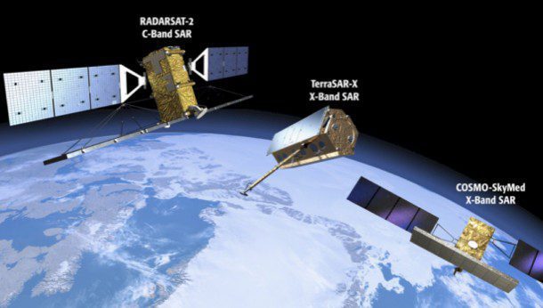
An ever-increasing number of Earth-observing radar satellites have employed SAR technology to obtain terrain and land-cover information about Earth.
By Rob Mott, vice president of Geospatial Solutions, Intergraph Government Solutions (www.intergraphgovsolutions.com), Madison, Ala.
Radar has become one of the most versatile remote sensing technologies of the last 100 years. Since the technology's rapid advancement played a significant role in the Allied forces emerging victorious in World War II, the broad-reaching importance of radar applications has become well known. From radar guns used by police officers to determine the speed of passing vehicles to Doppler radar weather detection systems or the radar-based collision detection systems installed in most modern automobiles, the technology's widespread applications enrich our daily lives.
Radar also is becoming a more prevalent component in many geospatial workflows and is an integral part of many military and civilian mapping applications. Early radar mapping solutions were complex and treated radar data in a standalone manner, but modern solutions make it easier than ever to harness the power of radar mapping data and seamlessly integrate such data with many other types of geospatial information.
Radar Advantages
Whereas optical imagery is passive remote sensing in which a target is illuminated by the sun and an optical sensor picks up the reflected sunlight, radar imagery is an active remote sensing technique that aims the controlled transmission of radio waves at a target followed by a synchronized collection of the radio waves reflected off that object. The object may be a moving vehicle, as in the case of a police officer's radar gun, or it may be a mountain range, as in the case of some space-based radar mapping systems.
Unlike optical imagery, which can be directly viewed and interpreted, radar data need to be processed or synthesized to generate a useful image or representation of the detected object or feature. In certain conditions, radar offers several advantages over optical imagery. For example, radar data can be collected at night, because the technology doesn't depend on visible light reflections. A second advantage is that radar collections can occur in bad weather, as radio waves can penetrate cloud cover and fog. Another interesting distinction is that while an optical image gives information about the chemical composition of the target material, a radar image can provide information about the material's physical structure and dielectric properties.
Data Diversity
With more systems and sensors coming online in the form of ground-based, airborne and space-based radar mapping platforms, it is more important than ever for organizations to process and analyze radar data as part of their geospatial workflows. Radar is best used in conjunction with other types of remote sensing data, such as light detection and ranging (LiDAR) data and overhead optical imagery. An integrated approach allows analysts to rely on other types of geospatial data collections to help understand the results obtained by the radar sensors. This additional detail and context helps operators and analysts make better-informed decisions.
Besides mapping, radar often operates in near real-time applications to enhance situational awareness and improve decision making. To support this development, several processing algorithms are recognized by the geospatial industry as state-of-the-art standards that help produce acceptable data-derived products from original radar data collections.
One of the most exciting advances in radar technology for geospatial workflows is the development of synthetic-aperture radar (SAR), which is characterized by the use of relative motion of the collecting platform (airborne or space-based). Essentially, a radio beam is dispersed from the platform toward the target; because the platform is in continuous motion, the collecting antenna is further down range by the time the reflected beam returns. This creates an artificially, or synthetically, large antenna, which improves the ability to create long-term coherent signal variations. These variations can be used to create detailed high spatial resolution and accurate 3-D reconstructions of objects and features on Earth's surface.
Land-based applications of SAR techniques include crop monitoring, geological surveys and numerous military applications. In addition, SAR technology is well suited for marine-based applications, including monitoring vessel traffic and mapping sea ice. Because radar systems can penetrate cloud cover, they can be deployed during hurricanes to accurately depict changes in underlying areas.
Maximizing Radar Use
Although there is a range of toolkits available to work with radar data, they can be complex and don't necessarily integrate with other geospatial applications. For organizations to maximize their radar use and open its potential to the widest number of individuals, the technology needs to be handled in a manner that removes the complexity, improves the ability to generate meaningful radar-derived results rapidly and integrates those results with other forms of geospatial data.
For example, these key objectives drove the development of the radar mapping capability included in Intergraph's ERDAS IMAGINE remote sensing application instead of a separate toolkit. This approach has been refined and is offered as a radar operational surveillance system (ROSS). The goal is to derive specific information and get it to decision makers as quickly as possible. A ROSS is optimized for accurately
extracting and tabulating desired information and handles long-term archiving and dissemination of the information to approved recipients.
A powerful analytical process to apply to SAR images is Coherent Change Detection (CCD), which takes two separate radar collections of the same area from two or more different moments in time and then uses a remote sensing application to compare the results. Change detection algorithms can identify unique differences between two images and provide color-coding to indicate what type of change has occurred.
For example, users can apply a blue highlight to objects or features that aren't in an earlier image but do appear in a more recent image, and a red highlight can be used to mark items that were in the first image but no longer appear in the second. An easy way to remember this approach is blue is new, and red has fled. The resulting highlighted areas can be further processed to extract specific features for use in a report or additional geospatial workflows. The regular use of CCD algorithms can provide analysts with a rich understanding of changes in a monitored environment over time.
Standardized output products are important components of this approach. The information must be in a format and style recognized by the widest possible audience. For example, the three bands of a red-green-blue image can be assigned in various ways, so it is important to use an accepted industry standard composite so everyone who looks at the image has a consistent interpretation. A change detection output, for example, may read, Red features are those that appear in the second image but not in the first. So something appeared in that time interval.
Output products, especially from radar imagery, need to be presented in a visual context to transmit the information's full impact. For example, radar-derived information, such as subsidence, may be blended with coregistered optical imagery to yield a product that allows the viewer to understand the subsidence in a geographic setting. Similarly, it might be best to overplot water-body boundaries during a flood on a before-flood optical image or a basemap to direct rescue efforts.
Data Management
A key component in the successful deployment of a radar surveillance capability across an enterprise is an image management engine, such as ERDAS APOLLO, that provides an image cataloging service, supports online imagery queries and serves/streams the results to users, including standardized output products. A robust image management engine also can be used to manage all of an organization's geospatial information, including optical imagery, LiDAR and GIS/vector data as well as radar-derived products and reports.
Additionally, a powerful feature of ERDAS APOLLO is the ability to launch complex radar processes as remote Open Geospatial Consortium-based Web processing services (WPSs) that can be initiated by any remote user, including those with handheld devices such as tablets or smart phones. The ability to ingest, or harvest, new radar imagery can be automated to a large degree, thereby improving the system's ability to provide analysts with the most recent and relevant imagery. Imagery also can be preprocessed automatically, and derivative products can be automatically generated.
Effective data management tools also can be configured to save, file and automatically disseminate reports according to customer specifications and protocols, thereby allowing users to subscribe to certain areas of interest or specific types of activities being monitored. In this configuration, a ROSS solution greatly frees a user's time, thereby increasing an organization's overall efficiency. Establishing these remote WPSs that work on radar data is the key to opening the power of radar to the masses without requiring advanced training or expensive solutions on each user's desktop. This has the advantage of reducing operating costs while supporting a wider range of missions.
Application Development
Radar applications have become vital and versatile additions to the geospatial community (see Radar Supports a Variety of Common Geospatial Applications, below. As applications for managing, processing and visualizing radar data continue to gain widespread popularity, more individuals and organizations will be able to harness the power of radar data in a reliable, economical, user-friendly manner. There will continue to be an increasing number of mapping and analytical applications as well as real-time operational applications. As more of these results are shared across governments and industries, new radar applications will continue to emerge.
Radar Supports a Variety of Common Geospatial Applications
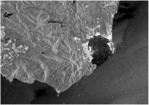
SAR data of the Strait of Gibraltar reveal many ships and oceanic features, including waves and sea-floor topography.
Based on an analysis of radar data use across the geospatial market, several applications stand out. These include, but are not limited to, oil slick monitoring, ship detection, wind fields extraction, ice mapping, and monitoring and surveillance for security purposes. These missions are sometimes intertwined and hence suggest a radar surveillance capability that produces multiple data-derived products from each dataset. Such applications also share a high-volume data stream and a need for timely analysis and information dissemination. A more detailed breakdown follows:
Ship Detection. The age of ships cruising the world's oceans unmonitored is over. In the near future, all ships will be monitored from departure to arrival just as aircraft are currently. The increasing requirement of on-board Automatic Identification System (AIS) transmitters substantiates this conclusion. The synergy between AIS and radar ship detection is high, reflected in the inclusion of this capability in the radar analysis system. Applications include vessel traffic control; human traffic, drug and weapon interdiction; and control of exclusive economic zones (EEZs)”especially illegal fishing and oil pollution. The driving requirement for ship detection with synthetic-aperture radar imagery is wide-area surveillance of the oceans, particularly where atmospheric conditions hinder surveillance with electro-optical sensors. It is anticipated that the demand for radar operational surveillance systems by countries with coastlines will increase rapidly during the next five years.
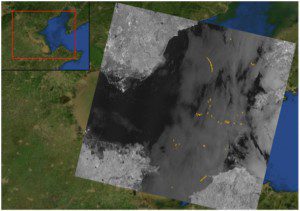
SAR data can help detect, quantify and track maritime oil spills, such as this March 2006 spill in China's Bohai bay.
Oil Pollution/Spill. This is already a major operational application. The Canadian and European governments have ongoing programs to monitor intentional and accidental oil discharges at sea at all times. As with ship detection, every country with a coastline will be a candidate for this type of application as will environmental protection agencies such as the U.S. Environmental Protection Agency and its international counterparts. It is also expected that major oil companies will invest in this type of application.
Oil Exploration. Radar imagery has a wealth of capabilities that appeal to oil companies. One is monitoring infrastructure for leaks and directing clean-up efforts. Given the huge costs associated with even unintentional leaks, this is a cost-effective application for every major oil company. Applications that apply to daily operations include routine and emergency monitoring of maritime production facilities, monitoring subsidence at production sites for enhanced recovery and field maintenance, mapping and routing for exploration and seismic surveys, subsurface structural mapping and mapping natural oil seeps at sea. In addition to the financial savings that will result from proactively addressing oil leaks in their early stages, this application provides additional benefits by helping these companies avoid huge fines and bad publicity.
Wind Fields. Wind speed and direction currently are monitored by floating buoys, which can be expensive to deploy and maintain and give only point-wise information. The ability to map detailed regional wind fields has sufficient interest to warrant several commercial software packages for this data-driven product. Applications include coastal weather and sea prediction, locating sites for wind generators, and acting as an auxiliary layer in monitoring or remediating oil spills.
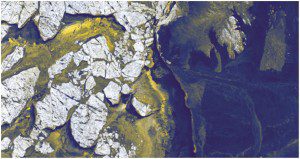
SAR data are used to track sea ice distribution, identify various types of ice and produce daily ice charts.
Sea Ice. This critical application was the primary factor in deploying Canada's RADARSAT-1 and RADARSAT-2 satellites and is routinely performed by several countries. Expanding trade through both the Northern Route (north of Asia) and the Northwest Passage (north of North America) will further necessitate radar operational surveillance systems.
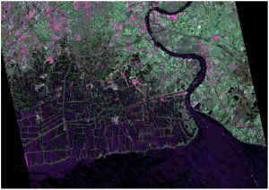
SAR imagery is a viable tool for coastal zone monitoring and applications where traditional optical sensors have met with limited success.
Shallow Bathymetry and Coast Delineation. The use of radar imagery for these applications has widespread applicability for analyzing harbors, ports and shipping lanes. Coastline mapping is an important component of erosion monitoring and evaluating destruction to coastal areas due to natural disasters such as hurricanes. Bathymetry mapping can bring strong value to coastal traffic control organizations and harbor management agencies.
Fisheries. Fisheries management and control is an important application area for radar operational surveillance systems. Given the high value of fish stocks and their catastrophic collapse worldwide, many countries are starting to more closely monitor their EEZs. Many fishing fleets engage in parasitic fishing as stocks decline. Indeed, radar images often reveal the line of the fishing fleet exactly corresponding to the EEZ line; most push right to the edge and others may attempt to slip over. As with oil spills, the effectiveness of the implementation is predicated on deterrence. By catching and fining some transgressors, others decide it isn't worth the risk. This role will fall to navies, coast guards and environmental protection agencies.

