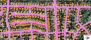
Aerial imagery guidelines developed by Loudoun County, Va., help ensure accurate base maps and analyses.
By Mita Mathur, Office of Mapping and Geographic Information, Loudoun County, Va.
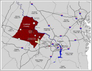
Located within the Washington, D.C., metropolitan area, Loudoun County is subject to intense development pressure.
Effective data management is the foundation for any successful mapping project. A well-defined quality assurance/quality control (QA/QC) plan sets expectations for data quality standards and describes methods and procedures for measuring data against those standards. Loudoun County, Va., has designed its QA/QC procedures and organized its workflows to make the best use of time, tools and people.
Maintaining an Accurate Base Map
Loudoun County covers approximately 520 square miles. Located within the Washington, D.C., metropolitan area, the county is subject to intense development pressure. Although the county's eastern portion is developing rapidly, many western areas remain wooded and agricultural. In recent years, however, development has expanded into historically rural areas. In addition, the county's topography is diverse, ranging from relatively flat plains to the crest of the Blue Ridge Mountains.
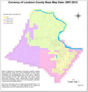
Loudoun County updates large, contiguous areas from aerial photography through stereo compilation and photogrammetry. The county has a seamless countywide base map geodatabase that can be used as a reference when mapping all other data. Each base map feature has an update date associated with it. If a feature hasn't changed in an area targeted for an update, the existing feature and prior update date will remain in place.
The county's base map maintenance project consists of acquiring aerial imagery and using the imagery to update its base maps”representations of the geographic features visible on the ground in an aerial image. Base maps provide the foundation or reference upon which other data layers can be developed or mapped.
Loudoun County was an early adopter of geographic information system (GIS) technology, beginning with its first GIS software purchase from Esri in 1986. Today the county operates a distributed GIS that is integrated with its other information systems.
Orthoimagery is the foundation of the county's GIS, which has approximately 220 internal users. Various departments depend on the county's orthoimagery and base map data to produce their own maps and analyses. The county's base map and other spatial data are maintained at a scale of 1:2,400.
The base map is a conventional photogrammetric product maintained annually from aerial photography. The Loudoun County Office of Mapping and Geographic Information (OMAGI) has generated countywide panchromatic/color orthos for several years, and the digital data are available on DVD from OMAGI's Public Information Counter. One-foot countywide digital orthos are available in the following formats:
¢ Uncompressed GeoTIFF covering 5,000- x 5,000-foot tiles each.
¢ Compressed MrSID covering 5,000- x 5,000-foot tiles each.
¢ Single compressed MrSID comprising the entire county.
Organizing Loudoun's QA Program
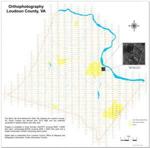
A grid defines the county's ortho tile indexing. The spatial location of photo centers, which are derived from recent flights, are relatively consistent year after year.
The county's QA program for orthoimagery and base map maintenance has been designed and developed at various levels:
¢ Project management level
¢ Project design level
¢ Project data assessment level
¢ Project reporting and oversight level
At the project management level, the nature and scope of the base map update project was reviewed and discussed in detail, and the purpose and objectives of the QA/QC plan were defined to ensure data quality. Acceptance criteria, schedule and the review process were defined at the project design level. Various QC checks, methods and tools that needed to be performed on the data were listed and described at the data assessment level.
QA/QC reporting and QC results during the course of the project were defined at the project reporting and oversight level. Once a QA plan was agreed upon by the project team, it was tested on a pilot project. Full production was initiated once the QA/QC plan was successful on the pilot database.
Developing Effective QA/QC Guidelines
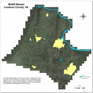
Loudoun's countywide mosaic is the end product of the orthoimagery QA/QC program and is widely used by the county's end users and citizens. Countywide mosaic checks are an important aspect of the program. The mosaic is visually inspected to ensure it is seamless and radiometrically homogenous across the entire county.
Orthoimagery consists of aerial images that combine the visual attributes of an aerial photograph and the spatial accuracy and reliability of a planimetric map. Orthoimagery is used as a backdrop with other data layers on top. For example, parcel boundaries can be layered on top of orthos. Therefore, QA/QC is an important component of the imagery product, as it serves as a reference layer for other datasets.
Loudoun's raster QA/QC methodology and supporting tools mainly include Esri's ArcGIS-based visual inspection tools. The county's QA/QC guidelines ensure that designated levels of QA/QC are performed during production phases and followed up by independent technical reviews. To ensure optimal accuracy, Loudoun's orthophotographs are reviewed against the following criteria:
Sheet conformance to Loudoun's ortho index grid. Loudoun County has a predefined ortho index grid with 684 tiles. The first QA/QC step is to make sure all the tiles conform to the grid and there's no gap or overlap between tiles.
Georeferencing. Georeferenced raster data can be viewed, analyzed and queried with other geographic datasets. The next step toward orthoimagery QA/QC is to make sure each image occupies the correct position with reference to the ground and conforms to the correct building and road-casing footprint.
Pixel definition and unit. Pixel means resolution. Loudoun's orthoimage resolution is 1 foot, so orthoimagery is checked to make sure the pixel size is 1 U.S. survey foot.
Sheet size. The orthoimagery program's sheet size is 5,000 feet (5,000 pixels) east-west by 5,000 feet (5,000 pixels) north-south. Images are checked against this criterion.
Projection and datum. Transforming a 3-D surface to create a flat map sheet by establishing the correct map projection or coordinate system may be the most important aspect of the county's QA/QC program. A datum is a standard position or level from which the measurements are taken. Loudoun's digital orthos are captured in VA North State Plane, NAD83 HARN and NAVD88, which are datums suitable for 1:2,400 mapping to National Standard for Spatial Data Accuracy (NSSDA) standards.
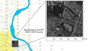
The first QA/QC step is to ensure all tiles conform to an ortho index grid with no gap or overlap between tiles.
Metadata. Metadata include important information about the orthoimagery. Federal Geographic Data Committee-compliant metadata that fully describe data compilation, quality and accuracy are created and checked for digital orthophoto products. Loudoun's orthoimagery metadata include how accurate and recent the orthoimagery is, use and sharing restrictions, important processes in the orthoimagery's life cycle such as compression and mosaicking, etc.
Tonal quality. Orthoimagery should have acceptable tonal balance across the entire project area. Orthophotos are checked visually for tonal balance so they can produce uniform contrast and tone across the image tiles of the entire project. Changes in color balance across the project, if they exist, should be gradual and minimal. Abrupt tonal variations between tiles aren't acceptable.
Scratches, image blemishes, debris and artifacts. Visual, qualitative checks for scratches, dust, threads, hotspots, haze, shadows, color seams, spilling and artifacts are important steps in a QA/QC plan. Image artifacts that are introduced during the production process and appear in the final orthophotos are unacceptable, except for minor artifacts that fall in noncritical coverage areas, such as a small piece of lint that appears in a wooded area.
Smears and other problems. During the QA/QC process, it's important to ensure the orthoimagery is free of smears, blurs, excessive glare or noise.
Warped or wavy features. Orthoimagery shouldn't contain any warped features. In addition, distinct linear ground features, such as roads and curbs, shouldn't deviate from their apparent path.
Clouds. Flying conditions, flight direction and time should be such that individual photos have tolerable cloud cover and sufficient contrast in features of interest. The QA/QC process ensures no clouds or cloud shadows appear on the imagery.
Mosaic lines. Orthoimagery is inspected to ensure mosaic lines through buildings and above-ground transportation structures are avoided to the greatest extent practical.
Shadows. Most of a project area is collected when the sun angle is 40 degrees or more. Shadows shouldn't be so dark that they obscure image content. In areas with tall trees or significant urban development with taller buildings, photography should be acquired when the sun angle creates minimal shadow.
Building lean. Bridges/overpasses and tall buildings should have minimal lean. These features shouldn't extend over adjacent roadways, sidewalks or parking lots. In the case of tall buildings, the lean may obscure ground features. The impact of building lean is most critical in urban areas with many tall buildings in a concentrated area. The QA/QC process helps to ensure orthorectification removes this issue and imagery is free from building lean.
Edge match and feature misalignment. Horizontal displacement along seam lines or at tile boundaries isn't allowed, as it's important to have seamless countywide imagery. Orthoimages are inspected for completeness to ensure no gaps or image misplacements exist within and between adjacent images. All orthoimages are inspected individually for feature misalignments along seamlines or between individual tiles to ensure complete coverage. Misalignment, especially in the case of transportation features between adjacent images, shouldn't exist.
Compression. Compression is applied to the GeoTIFF imagery to reduce the large data volume of high-resolution images. Manipulating large data volumes can be challenging for certain analyses. Compression serves two important purposes for Loudoun County: mosaicking and distributing imagery to the public on a single DVD. Loudoun's orthoimagery is compressed in JPEG 2000 and MrSID format. Compression techniques involve some information loss from the original imagery, but a visual check ensures such information loss is minimal.
Mosaicking. Mosaicking is done to produce a seamless orthoimage of a large area. To achieve this goal, input images should have consistent geometric and radiometric characteristics so seams will be as invisible as possible in the output countywide mosaic. The mosaic should be tone balanced and maintain as much of the original color and appearance of the color-corrected tiles as practical. The mosaic is the end product and is used widely by the county's citizens. Therefore, countywide mosaic checks are one of the important aspects of Loudoun's QA/QC program. It's important to ensure the mosaic is seamless and radiometrically homogeneous across the county.
Accuracy. The orthoimagery digital files are in compliance with digital geospatial data accuracy standards according to NSSDA, which implements a statistical testing methodology for estimating the positional accuracy of points in digital geospatial data with respect to georeferenced ground positions of higher accuracy. Previously surveyed check points are used to report accuracy assessment.
Reaping the Rewards of a Reliable Foundation
These guidelines play an important role in Loudoun County's orthoimagery QA/QC specifications. Such QA/QC processes give users confidence in the data and ensure a high level of accuracy and quality.
Orthophotographs are important to Loudoun County, as they're used as a reference when mapping all other data. Datasets such as parcels, addresses, street centerline, zoning and planning districts often rely on imagery datasets. It's critical for local governments to develop well-designed QA/QC procedures to ensure a reliable foundation for their orthoimagery data.
Acknowledgements
The author would like to thank Larry Stipek, Kristin Brown, Doug Gibson and Stephen Zlato for their feedback and assistance; her spouse Jaswant, mother Sudha, sister Milan and brother Anupam for inspiration and support; and Shawn Benham and Sanborn Map Company for making this article possible.

