This photograph was taken by a member of the Expedition 48 crew and provided by the ISS Crew Earth Observations Facility and the Earth Science and Remote Sensing Unit, Johnson Space Center. The image has been cropped and enhanced to improve contrast, and lens artifacts have been removed. (Credit: NASA)
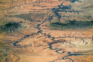
A panorama photograph taken by an astronaut aboard the International Space Station shows nearly the full length of Lake Powell, the reservoir on the Colorado River in southern Utah and northern Arizona.
At full capacity, the reservoir impounds 24,322,000 acre-feet of water, a vast amount that is used to generate and supply water to several western United States, while also aiding in flood control for the region. It is the second-largest reservoir by maximum water capacity in the United States (behind Lake Mead).
Green forests indicate two high places in the image that are cooler and receive more rain than the dry, low country surrounding the lake. The isolated Navajo Mountain is a sacred mountain of the Native American Navajo tribe and rises to 3,154 meters (10,348 feet). The long, narrow Kaiparowits Plateau rises nearly 1,200 meters (4,000 feet) from Lake Powell to an elevation of more than 2,300 meters (7,550 feet). More than 80 kilometers (50 miles) long, the plateau gives a sense of horizontal scale.
