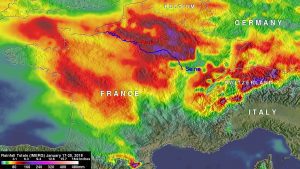
NASA IMERG rainfall accumulation data generated during the period from January 17-25, 2018, showed the highest rainfall totals occurred along the Seine River east of Paris. These IMERG estimates indicate that rainfall totals greater than 180 mm (7 inches) occurred in this area where the Seine River flows toward Paris. (Credit: NASA/JAXA, Hal Pierce)
Eastern France has experienced unusually heavy rainfall in early 2018, and NASA satellite data has helped determine where the largest rainfall occurred.
The national weather agency for France has put out orange alerts for flooding in large areas of France. Frequent rainfall has caused widespread flooding along the Seine River that flows through Paris. Paris has had flooding similar to the June 2016 inundation when water levels reached more than six meters (20 feet).
The Global Precipitation Measurement mission or GPM core satellite can measure precipitation from space. GPM is a joint mission between NASA and the Japan Aerospace Exploration Agency, JAXA. There's also a GPM constellation of satellites that provide additional rainfall data to provide a more comprehensive picture of events.
At NASA's Goddard Space Flight Center in Greenbelt, Maryland, an analysis was conducted using NASA’s Integrated Multi-satellitE Retrievals for GPM (IMERG) data generated during the period from January 17-25, 2018. The data acquired from the GPM constellation of satellites are used to make the IMERG product. IMERG data are calibrated using Microwave Imager (GMI) and Dual-Frequency Precipitation Radar (DPR) data received by the GPM core observatory satellite.
