May 27, 2016
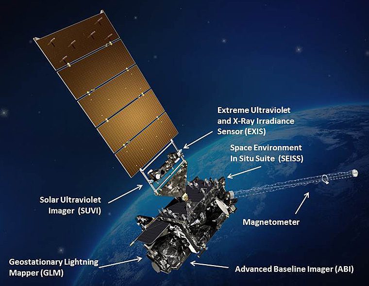
Planned for launch on Oct. 13, 2016, the Geostationary Operational Environmental Satellite-R Series (GOES-R or GOES-16 as it will be known once operational), is the first of a new generation of geostationary weather satellites that will include GOES-S, T and U.
March 31, 2016
Established in 1978, FLIR Systems designs, develops, manufactures, markets and distributes systems for thermal imaging, visible-light imaging, measurements and diagnostics, and advanced threat detection.
February 2, 2016
Sofradir has had an active role in space missions for Earth observation, scientific exploration and weather since 1994. It is the only European infrared (IR) manufacturer to have its detectors deployed in space, with proven performance, robustness and reliability.
December 5, 2015
Unmanned Aircraft System (UAS) manufacturer senseFly was the first to bring RTK survey-grade mapping to a UAS platform with its fixed-wing senseFly eBee RTK in June 2014. This platform is capable of three-centimeter accuracy without the need for ground-control points, which aids efficiency for precision-mapping efforts. “I am a surveying engineer and have worked
September 28, 2015
Ball Aerospace has been actively developing its TotalSight Flash LiDAR system for the last six years. Flash LiDAR works much like a traditional digital camera, with the sensor taking a range and intensity snapshot with each laser pulse.