July 30, 2015 — Airbus Defence and Space, owner of the commercial distribution rights for TerraSAR-X data, and ESA have signed a contract securing the continued supply of TerraSAR-X data for the Copernicus Data Warehouse. The agreement is valid until the end of...
Surfing for Science
July 29, 2015 —Thanks to a new system developed by scientists in the UK, taking to the waves for a spot of surfing can benefit research into the health of coastal waters, and could help confirm satellite measurements of sea-surface temperature. The system, developed...
First Applications from Sentinel-2A
July 28, 2015 — From agricultural monitoring to charting changing lands, early images from Europe’s new Sentinel-2A satellite show how the ‘colour vision’ mission’s critical observations can be used to keep us and our planet safe. Launched from Europe’s...
Searching for Underground Energy Sources from Space
July 27, 2015 — Data from ESA’s GOCE gravity satellite are being used to improve models of Earth’s geology, indicating the potential locations of subsurface energy sources. The satellite known as the ‘Ferrari of space’ has measured Earth’s gravity with...
Planet Labs to Acquire BlackBridge
On July 15, 2015, BlackBridge, a provider of satellite imagery and geospatial solutions, entered a definitive agreement for Planet Labs to acquire the RapidEye suite of core offerings. Planet Labs designs, builds and operates a fleet of Earth-imaging satellites.
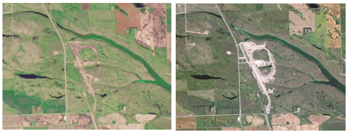
Satellites Support Crop Yield Estimations in Turkey
July 20, 2015 — Airbus Defence and Space delivers SPOT 6 and SPOT 7 satellite data in support of the TARBIL (Agricultural Monitoring and Information System Project) project in Turkey. TARBIL is a highly technological and comprehensive agricultural monitoring project...
UrtheCast Closes Acquisition of Earth Observation Satellites and Business Operations from Elecnor
VANCOUVER, July 16, 2015 — UrtheCast Corp. (TSX:UR) ("UrtheCast" or the "Company") today announced that its subsidiary has closed its previously-announced acquisition (the "Acquisition") of the Earth Observation business dba Deimos Imaging and DOT Imaging ("Deimos...
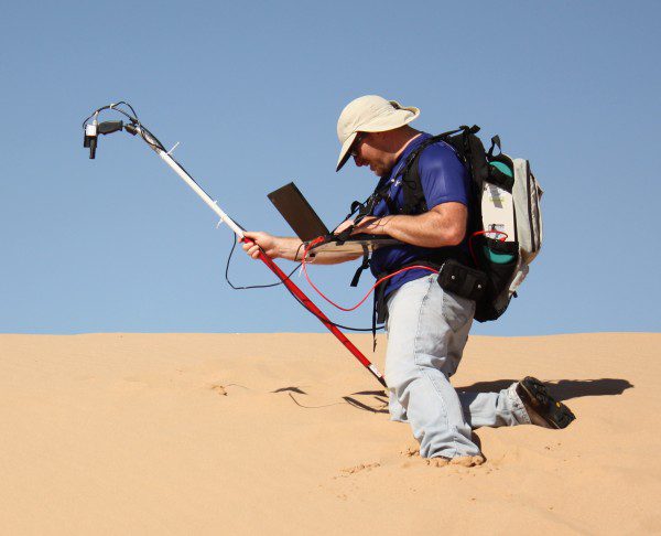
Finding Stable Sites to Calibrate Orbiting Satellites
South Dakota State University (SDSU) imaging engineer Larry Leigh will use Google Earth images to find sites to calibrate Earth-imaging satellites, thanks to a one-year, $46,000 Google Earth Engine Research award. He's the first SDSU researcher to receive the award.
Airbus Defence and Space Signs First Contract for Flexible Quantum Satellite with Eutelsat and ESA
July 9, 2015 — Airbus Defence and Space has signed the first contract for the fully reconfigurable Quantum satellite with Eutelsat and the European Space Agency (ESA). The Quantum satellite will be operated and commercialised by Eutelsat and will be able to adapt to...
Ball Aerospace Powers on NOAA’s JPSS-1 Weather Satellite
BOULDER, Colo., July 2,2015 — Ball Aerospace & Technologies Corp. has powered on the Joint Polar Satellite System (JPSS-1) satellite for the first time. The JPSS-1 is the nation's next polar-orbiting, environmental satellite, scheduled to launch in 2017....
