SAN FRANCISCO, June 23, 2015 — A venture-backed Silicon Valley company, Spaceknow is launching an online service for the automated analysis of satellite imagery to debut at the GEOINT 2015 Symposium. As the lead provider of satellite imagery-derived products,...
Collaboration set to Map Path for Ecologically and Sustainable Economic Growth
June 18, 2015 — Ecometrica, the world-leading sustainability software and data company, has partnered with scientists at Edinburgh Napier and other universities to build an application that will help developing world governments ensure their economic growth is...
Getmapping Partners with PlanetObserver to Provide Global Satellite Imagery and Height Data
Hartley Wintney/Clermont-Ferrand, April 23, 2015 —– Getmapping has partnered with PlanetObserver to offer customers a full range of global and regional Earth satellite imagery along with two global height data options. The partnership is in line with...
LizardTech to Exhibit at Several Conferences this Spring
SEATTLE, Wash., April 22, 2015 — LizardTech®, a provider of software solutions for managing and distributing geospatial content, is heading into a busy conference season exhibiting at four different tradeshows this spring. Showcasing the company’s entire line of...
UC San Diego Granted Access to DigitalGlobe Commercial Satellite Imagery
March 24, 2015 — The DigitalGlobe Foundation has selected the University of California, San Diego to be one of two institutions of higher learning given open access to DigitalGlobe Basemap, an online map and database of current, high-resolution satellite imagery –...
DigitalGlobe Announces Availability of 30 cm Satellite Imagery to All Customers
LONGMONT, Colo.--(BUSINESS WIRE)--Feb. 25, 2015— DigitalGlobe, Inc. (NYSE: DGI), a leading global provider of high-resolution earth imagery and geospatial solutions, today announced the full availability of 30 cm satellite imagery products, an industry first that...
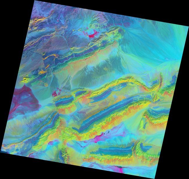
Mapping Minerals with Light
The spectacular exposed geology of northwestern China offers an ideal landscape for illustrating how satellite measurements can identify minerals from afar.
