March 25, 2015 — The U.S. Geological Survey National Geospatial Program is pleased to announce the first round of awards resulting from the USGS Broad Agency Announcement (BAA) for the 3D Elevation Program (3DEP), initially issued on July 18, 2014. (Solicitation...
Dielmo 3D to Demonstrate LiDAR Processing, Software and Online LiDAR Services at ILMF 2015
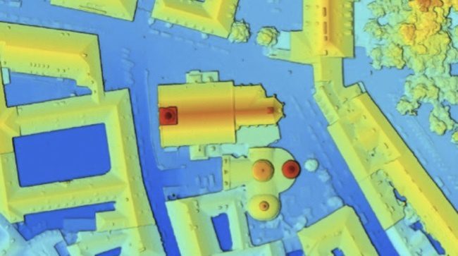
Valencia, Spain, Centennial CO, Feb. 19, 2015—DIELMO 3D S.L., Valencia, Spain, announced they will be demonstrating their LiDAR industry leading online services as well as proprietary LiDAR software and processing services at ILMF 2015. Additionally, Dielmo 3D has...
Dewberry Selects LP360 for LIDAR Workflows
Huntsville, Ala., Feb. 16, 2015—QCoherent Software is pleased to announce that Dewberry has purchased multiple copies of LP360 for use in a variety of LIDAR workflows. Amar Nayegandhi, Associate Vice President and Director of Remote Sensing, oversees LIDAR data...
Aerial Imaging Primer: Moving Beyond the Base Map
Aircraft have several advantages over satellite platforms when collecting imagery. For example, aircraft can collect data on specific dates and times. Another advantage is the ability to put new sensors in aircraft as technology advances.
Sewall and RC&A Team for Aerial Imagery, LiDAR
Old Town, Maine, Jan. 15, 2013—Sewall and its long-term aerial subcontractor Richard Crouse & Associates, Inc. (RC&A), have entered into a teaming agreement to expand mutual capabilities, services and client base in aerial image and LiDAR data acquisition....
Transportation Management: LiDAR, Satellite Imagery Expedite Infrastructure Planning
By Waheed Uddin, professor of civil engineering and director, Center for Advanced Infrastructure Technology (www.olemiss.edu/projects/cait), University of Mississippi, University, Miss. For years, transportation projects have benefitted from aerial photography and...
