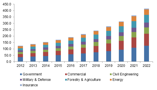
According to a new research report by Global Market Insights, the aerial imaging market is estimated to grow to $2.64 billion by 2022.
According to a new research report by Global Market Insights, the aerial imaging market is estimated to grow to $2.64 billion by 2022.
TerrAvion, which helps farms take a high-tech approach to improving yield and revenue, announced today the first aerial imaging solution specifically designed for rangeland. The service provides current images and data that help cattle ranchers spot early-warning...
Phase One Industrial has today introduced the Phase One 4-Band Solution. The solution incorporates an innovative batch-processing tool that automates and thus simplifies the four band aerial image generation process. Adding a fourth band of near infrared (NIR) image...
Albany, NY, October 30, 2015 —  This research report titles "Aerial Imaging (Energy, Geospatial technology, Natural resources management, Construction, and Defense) Market – Global Industry Analysis, Size, Share, Growth, Trends, and Forecast, 2014 – 2020"...
SAN JOSE, CA, September 25, 2015 — Creative aerial imaging has been driving mass adoption of camera drones and Eric Cheng, Director of Aerial Imaging of DJI and General Manager of DJI SF, will lead a dynamic session at the upcoming Drone World Expo focusing on...
STUTTGART, Germany, Sept. 15, 2015 — Trimble (NASDAQ: TRMB) announced today it will demonstrate its comprehensive portfolio of Geospatial solutions at INTERGEO 2015. Trimble’s portfolio of aerial imaging, mass and point data capture, GIS mapping and terrestrial...
Graz, September 8, 2015 – HolisticImaging™, is pleased to announce the release of UnlimitedAerial™ version 1.1, which adds UAS support, oblique camera support and orthophoto support to our production pipeline. Naturally, all our algorithms are designed to handle...
SUNNYVALE, Calif., August 25, 2015 —Trimble (NASDAQ: TRMB) announced today the ZX5 Multirotor Unmanned Aircraft System (UAS), a new aerial imaging and workflow solution that captures and processes geo-referenced photo and video data for mapping, agriculture and...
Aircraft have several advantages over satellite platforms when collecting imagery. For example, aircraft can collect data on specific dates and times. Another advantage is the ability to put new sensors in aircraft as technology advances.
