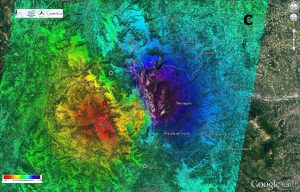
Scientists combined several pairs of Copernicus Sentinel-1 radar images acquired between Oct. 25-Nov. 1 to analyze ground displacement caused by the October 30 earthquake. (Credit: Contains modified Copernicus Sentinel data (2016)/ESA/CNR-IREA)
Scientists from Italy's Institute for Electromagnetic Sensing of the Environment of the National Research Council as well as the National Institute of Geophysics and Volcanology used radar imagery from the Copernicus Sentinel-1 satellites to identify significant east“west ground displacement in central Italy where an earthquake struck on Oct. 30, 2016.
An eastward shift of about 40 centimeters was mapped in the vicinity of Montegallo, while a westward shift of about 30 centimeters was found in the area of Norcia. Vertical displacement also is evident, with the ground sinking 60 centimeters around Castelluccio, but rising by about 12 centimeters around Norcia.
The Italian peninsula is prone to earthquakes because of the continuing collision of the African and Eurasian tectonic plates. Under the Apennine mountain chain, the regional collision is causing the African slab to flex and dip under the Tyrrhenian Sea, while at the same time retreating northeast.
Sentinel-1 is not the only satellite providing information on this recent quake: scientists also are relying on the Italian space agency's Cosmo-SkyMed satellites as well as satellite images from other space agencies.

