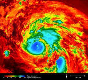
 The Europeans Space Agency (ESA) Copernicus Sentinel-3A satellite monitored the temperature at the top of Hurricane Harvey on Aug. 25, 2017, as the storm approached the U.S. state of Texas.
The brightness temperature of the clouds at the top of the storm, some 12-15 kilometers above the ocean, range from about -80°C near the eye of the storm to about 20°C at the edges. Sentinel-3's Sea and Land Surface Temperature Radiometer measures energy radiating from Earth's surface in nine spectral bands and two viewing angles.
Photo Credit: Contains modified Copernicus Sentinel data (2017), processed by ESA.
