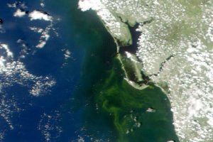
A natural-color MODIS satellite image shows algae staining the water off the coast of Fort Myers, Fla., on Aug. 19, 2018. (Credit: University of South Florida Near Real-Time Integrated Red tide Information System)
Put a sample of water from the Gulf of Mexico under a microscope, and you will often find cells of Karenia brevis swimming around. The microscopic algae”the species of phytoplankton responsible for Florida's worst red tide outbreaks”produce brevetoxin, a compound that in high concentrations can kill wildlife as well as cause neurological, respiratory and gastrointestinal issues for people.
Under normal conditions, water-quality tests find, at most, a few hundred K. brevis cells per liter of water”not enough to cause problems. But in August 2018, in the midst of one of the most severe red tide outbreaks to hit Florida's Gulf Coast in a decade, water samples regularly contained more than one million K. brevis cells per liter.
That was enough to stain large swaths of coastal waters shades of green and brownish-red, and leave beaches littered with rotting fish carcasses. Roughly 100 manatees, more than 200 sea turtles, and at least 12 dolphins have been killed by red tides, according to preliminary estimates. For much of August, the toxic bloom stretched about 130 miles (200 kilometers) along Florida's Gulf coast, from roughly Tampa to Fort Myers. Although the bloom has been active since October 2017, it intensified rapidly in July 2018. The damage grew so severe and widespread that Florida's governor declared a state of emergency in mid-August.
One of the best ways to test for the presence of K. brevis is to analyze water samples collected from boats or beaches. State environmental agencies do this on a regular basis, but understanding the full extent and evolution of fast-changing blooms”or predicting where they will move”with ground sampling alone is a challenge.
That's why key red tide monitoring systems, such as the National Oceanic and Atmospheric Administration's Harmful Algal Bloom Forecast System and the Near Real-Time Integrated Red Tide Information System from the University of South Florida, make use of satellite data from the Moderate Resolution Imaging Spectroradiometer (MODIS) sensors on NASA's Aqua and Terra satellites. These sensors pass over Florida's Gulf Coast twice a day, acquiring data at several wavelengths that can be useful for identifying and mapping the spatial extent of algal blooms. Other satellite sensors such as the Visible Infrared Imaging Radiometer Suite (VIIRS) on Suomi NPP and the Ocean and Land Color Instrument (OCLI) on Sentinel-3 collect information that can be used to monitor red tides.
