NASA's Aqua satellite passed over Hurricane Willa on Oct. 23, 2018, and analyzed it in infrared light. Powerful storms (purple) with very cold cloud-top temperatures circled the center and stretched northeast over western Mexico. (Credit: NASA JPL, Heidar Thrastarson)
NASA's Aqua and Suomi satellites provided views of Hurricane Willa as it continued moving toward landfall in western Mexico. Willa is expected to bring life-threatening storm surge, wind, and rainfall to portions of west-central and southwestern Mexico.
On Oct. 22, NASA-NOAA's Suomi NPP satellite captured a visible image of Hurricane Willa when it was battering western Mexico with heavy rainfall, rough surf and strong winds. The image showed powerful thunderstorms circling a cloud-filled eye and the storm stretched from Sinaloa state south to Michoacan state.
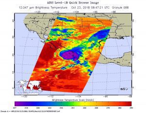
NASA's Aqua satellite passed over Hurricane Willa on Oct. 23, and the Atmospheric Infrared Sounder (AIRS) instrument aboard analyzed cloud-top temperatures using infrared light. Coldest cloud-top temperatures were as cold or colder than 208 Kelvin or minus 85.2 degrees Fahrenheit (minus 65.1 Celsius). Cloud-top temperatures that cold indicate strong storms that have the capability to create heavy rain.
