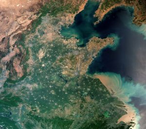
 The Copernicus Sentinel-3A looks at an extremely populous portion of Asia, including Shanghai, China, home to more than 24 million people, which is visible in the lower right of the image just above the Yangtze River mouth. As a significant global financial center, it's also one the world's busiest container ports because of its strategic location on the Yangtze River delta.
The image covers an area of more than 1,200 kilometers, showing Beijing (at the center-top), home to nearly 22 million people; the salt flats close to the Mongolian border in the top left; and North Korea, with its capital, Pyongyang, just visible in the top right of the image. A large number of urban settlements represented as grey flecks are interspersed with agricultural fields, dominating the central part of the image.
This true-color image taken using Sentinel-3A's Ocean and Land Colour Instrument (OLCI) shows the huge amount of sediment carried into the ocean along the coast.
Meanwhile, Taihu Lake is shown in green in the lower right part of the image. In 2007, an algal bloom on the lake caused major problems with water supplies in the neighbouring city of Wuxi. Such algal blooms may well be linked to the discharge of phosphates found in fertilizers used in industry and agriculture into the water.
Steps have been taken to limit the use of such fertilizers in a bid to reduce algal blooms, which can significantly alter the ecology of the environment below the surface and pose a threat to various forms of water life.
Photo credit: Contains modified Copernicus Sentinel data (2017), processed by ESA
