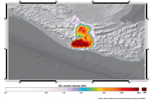
 On June 3, 2018, the Copernicus Sentinel-5P satellite measured sulphur dioxide in the plume spewing from the Fuego volcano in Guatemala. The eruption has already claimed 25 lives and injured several hundred. It is reported to be Guatemala's deadliest such event since 1902 when the Santa Maria volcano erupted and killed thousands of people. The Fuego volcano, which is less than 40 kilometers southwest of the capital Guatemala City, also erupted in February 2017 and sent ash almost 2 kilometers high. The 2018 event was much larger with ash reaching 6 kilometers high, and hot rock and gas engulfing nearby villages.
Launched in October 2017, the Copernicus Sentinel-5P data products are still being validated before their release to the public. However, this image clearly shows high amounts of sulphur dioxide being ejected into the atmosphere. The satellite carries the Tropomi instrument to map a multitude of trace gases such as nitrogen dioxide, ozone, formaldehyde, sulphur dioxide, methane, carbon monoxide and aerosols.
(Photo Credit: Contains modified Copernicus Sentinel data (2018), processed by DLR/BIRA)
