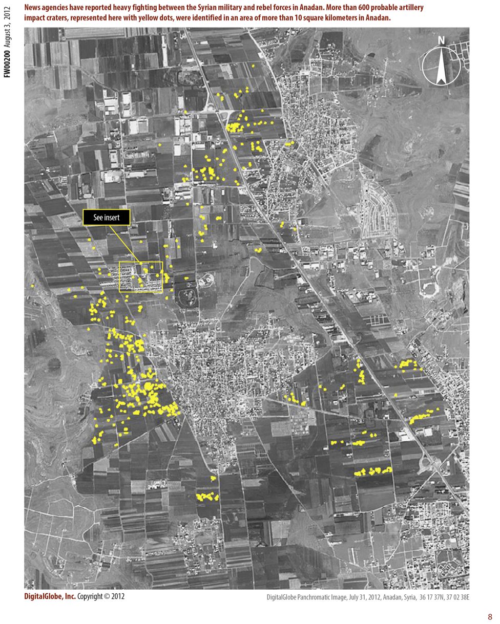
Emergency Response DigitalGlobe has formed an imagery and geospatial Analysis Center to support humanitarian relief and human security activities around the world. Using DigitalGlobe’s FirstLook service as a platform, the DigitalGlobe analysis team identifies...
Global Population Mapping Tool Sets the Standard
Disaster Response When tsunamis struck the Indonesian coast in December 2004, the destruction left relief agencies scrambling to locate thousands of stranded people in need of assistance. LandScan Global (LandScan), a worldwide population database developed by the...
Benefit from a New Wave in Satellite AIS Technology
Maritime Security With the recent launch of the exactView-1 (EV-1) micro-satellite and the announcement of a new premium service that fuses multiple sources of ship Automatic Identification System (AIS) data from space and land, the complete maritime picture never has...
Providing a Secure Print Environment for Sensitive Data
Printing and Display Protecting sensitive data throughout the workflow is a key consideration for public-sector institutions, commercial business and geospatial intelligence (GEOINT) professionals. Often overlooked when dealing with securing such data is the output...
Powering Applications with Map Data Layers Extracted from Satellite Imagery
Visualization/Simulation Simulation-based virtual training systems require geo-specific visual environments for realistic training of military and security forces, but scenarios often are based in areas of the world with limited map data availability. LAND INFO...
Gathering Intelligence Faster than Real Time
Big Data Management The real-time intelligence generated from the fastest-growing nation on Earth—the Social Media Nation—is incredibly valuable for analysts seeking to keep the peace, managing emergencies and fighting terrorism. But how can it be taken one step...
Automated Extraction Solution Meets Demanding Requirements
3-D GEOINT Overwatch’s optimized solutions dramatically reduce the time required to produce high-quality 3-D GEOINT products. Identifying the Problem High-resolution 3-D terrain and mission modeling helps decision makers understand the real-world conditions they...
London 2012 Olympics: Mapping the Playing Field with Qbase’s MetaCarta GSRP
Geosearch and Georeferencing When London was awarded the 2012 Olympics in mid-2005, Assistant Chief Constable Steve Thomas was asked to lead the British Transport Police (BTP) and the Olympics project in preparing for the massive security effort to protect rail,...
Pan-sharpening: Solving Consistency and Complexity Problems
Image Fusion For the defense industry, the ability to have accurate color satellite image information is invaluable. Satellite data can be generated daily and from a safe distance. This means a target can be monitored for changes in activities real time and with...
Accessing Previously Unattainable Solutions
Geospatial Data and Model Discovery In the age of big data, the volume of geospatial information available through disparate sources can be overwhelming. Even the most sophisticated users often struggle to discover the right data and models to make decisions and solve...