Google Buys Skybox Imaging for $500 Million Google agreed on June 10, 2014, to buy Skybox Imaging, a provider of high-quality satellite images, as the technology giant continues its lofty ambitions for its Internet offerings. Initially, Skybox will help improve...
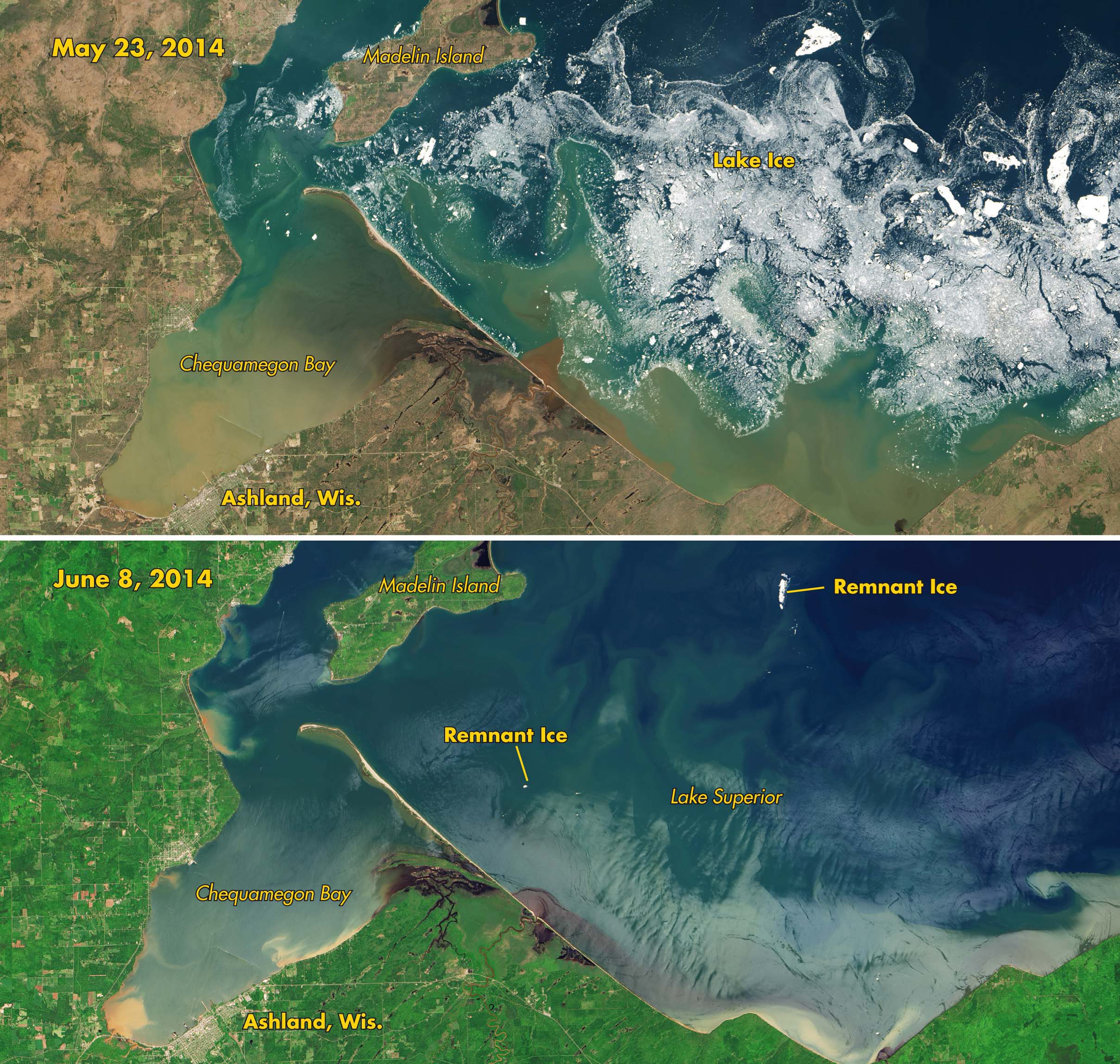
Swimming with Ice Cubes in Lake Superior
Air temperatures in the states and provinces around the Great Lakes suggest that meteorological summer has arrived. But the icy grip of winter is lingering in cool water temperatures and drifting chunks of ice. For nearly seven months, ice has been afloat somewhere on...
Lake Erie Ice Thickest in Decades
The intense cold snap that gripped much of central Canada and the United States in early January 2014 brought thick and widespread ice to the Great Lakes. Though parts of the lakes freeze every winter, several news media and meteorologist accounts suggested that...
Industry Updates Nov/Dec
DigitalGlobe Launches Educational Foundation DigitalGlobe launched the DigitalGlobe Foundation, a nonprofit organization focused on fostering the growth of the next generation of geospatial technology professionals. “The foundation was established on the belief that...
Industry Updates
Click here to see our "Industry Updates Article"
Global Experts: It's Time to Address Space Debris
There’s an urgent need to remove orbiting space debris and to fly satellites in the future without creating new fragments, according to experts at Europe’s largest-ever space-debris conference. According to findings from the Sixth European Conference on Space...
Industry Updates
Astrium Seeks Partner for New Real-Time EO Satellite Astrium is speaking to countries outside Europe, including Singapore, about partnering to develop GO-3S, the company’s new geostationary Earth observation (EO) satellite. Gregory Pederson, Astrium sales and...
Imagery Updates
Climate Models Project Increase in U.S. Wildfire Risk Scientists using NASA satellite data and climate models say drier conditions likely will cause increased fire activity acrossthe United States in coming decades. Other findings about U.S. wildfires, including their...
Industry Updates
Commercial Data Market Slows But Remains Strong According to Euroconsult’s latest research report, Satellite-Based Earth Observation: Market Prospects to 2021, the 2011 market for commercial Earth observation data grew only 6 percent to $1.4 billion, following five...
Industry Updates
SPOT 6 Delivers First Images Astrium Services posted the first SPOT6 satellite images, just three days after its launch on Sept. 9, 2012. Like its twin SPOT7, which is slated for launch in early 2014, SPOT 6 has a 60-kilometer swath width and produces imagery...
