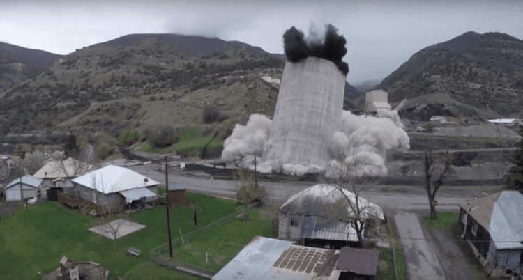
Steve Huntley is something of a character in Paonia, Colo., my hometown. Lately, his UAS videos of local scenes and events have been making a splash. His recording of the controlled demolition of the Oxbow Mining Silo was a big, if controversial, hit”the silo's local landmark status and association with the coal industry made its destruction a flashpoint for the region's progressives and conservatives.
Remote-Sensing Renaissance Leads the GEOINT Revolution
There's something incredibly powerful going on right now, something the USGIF refers to as the Geospatial Intelligence (GEOINT) Revolution. It represents the synergy of remarkable advances happening simultaneously across multiple technology areas. When combined, this cooperative interaction fundamentally changes our individual and collective ability to deal with our construct of spatial thinking and awareness, altering our ability to apply space over time to a range of tasks, missions and disciplines in a way we hadn't imagined.
Coastal Monitoring Provides an Opportunity for Oil and Gas Projects
Deepwater Horizon”the memories are fading, but the negative effects still are being felt six years later and will be for a while to come. Much has been said about the impacts on the wildlife, coastal ecosystems, fisheries, tourism and other parts of the local environment and economy.
Compounding Collection Capacity
I recently had the distinct pleasure of addressing the U.S. Park Service, and U.S. Fish and Wildlife Service Geospatial Training Workshop at the National Conservation Training Center outside Shepardstown, West Virginia. The talk was an overview of how far we've come as well as where we're headed in terms of remote-sensing inputs and geospatial understanding.
Defining ˜First Principles' of Geospatial Intelligence
In 2015, I developed and taught a free Massive Open Online Course (MOOC), Geospatial Intelligence (GEOINT) and the Geospatial Revolution, to help broaden the discipline. When I began outlining the course, I asked several in the community, what should be the focus of the MOOC? The common reply was teach the principles.
Coastal-Erosion Modeling with LiDAR and UAS Technology
Coastal erosion is a persistent problem along the California coast that can drastically affect local communities. In the last 20 years alone, erosion has taken a particularly high toll in Pacifica, Calif. Through wind, rain and wave action, the scenic bluffs that line the ocean in this beachside town have continued to retreat to a point where local homes have been evacuated and condemned for demolition.
The UAS Wild West: Are Standards Needed?
Right now, it's kind of a Wild West out there, says Scott Simmons, executive director of the Standards Program of the Open Geospatial Consortium (OGC).
NASA Adds GIS Features to Giovanni
Starting in 2004, the NASA Goddard Earth Sciences Data and Information Services Center (GES DISC) has provided an innovative and useful way to look at NASA Earth science data using the Web.
Disruptive Combinations Forge the Future
Everywhere we turn these days, there's yet another disruptive technology seemingly set to take the world by storm with increased automation and reduced cost.
UAS Growth: Fast, Cheap, Out of Control?
Those of us who have been following infrastructure for more than a couple of decades are astonished, and unimpressed, by the seemingly sudden emergence of unmanned aircraft systems (UASs) as critical technology for infrastructure solutions of all sorts, particularly mapping and surveying.