COVINGTON, La.- Globalstar, Inc. (NYSE MKT:GSAT) announced today that the University of Miami Rosenstiel School of Marine and Atmospheric Science (UM) will be deploying 550 SPOT Trace satellite trackers in its continued research expedition with the Consortium for...
Ecometrica Lands on FT1000 List of Europe’s Fastest Growing Companies
Edinburgh/London - Sustainability software and data company Ecometrica, best known for its satellite mapping applications that show the effects of deforestation and climate change, has succeeded in being placed 388th on the FT1000 list of Europe's fastest growing...
Eye In The Sky: UTC Aerospace Systems MS-177 Sensor Enables U.S. Military To See Farther Than Ever Before
CHARLOTTE, N.C.- The U.S. military will soon be able to see airborne images at a greater distance and with greater clarity than ever before now that UTC Aerospace Systems, a unit of United Technologies Corp. (NYSE:UTX), has successfully completed the first flight test...
Merrick Releases MARS 2017 Software Suite
Greenwood Village, CO – April 13, 2017 – Merrick & Company, a global leader in light detection and ranging (LiDAR), digital orthophotography, hyperspectral imaging, and geographic information systems (GIS) data integration, is pleased to announce the release...
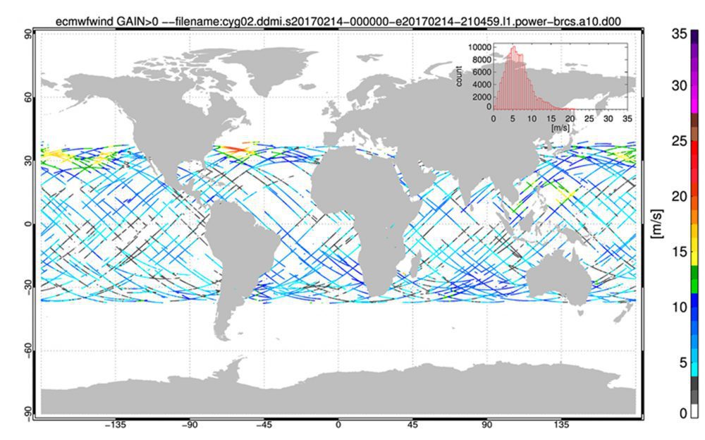
NASA's CYGNSS Constellation Enters Science Operations Phase
NASA's Cyclone Global Navigation Satellite System (CYGNSS), a constellation of eight microsatellites that will take detailed measurement of wind speeds inside hurricanes, successfully completed the development and on-orbit commissioning phases of its mission and moved into the science operations phase.
DroneDeploy Integrates with agX to Streamline Planning of Drone Mapping Flights
Stillwater, Okla.- STILLWATER, OK – DroneDeploy, the leading cloud software platform for commercial drones today announced an integration with agX® to help growers more easily capture field maps and analyze aerial data. agX users can now share field boundaries...
Martin Instrument Adds Microdrones UAVs to Their Offering
US: Microdrones has announced that leading equipment provider for surveying and construction companies throughout Texas, Martin Instrument, has added a new product line to their extensive offering: Microdrones mdMapper unmanned aerial systems. These complete solutions...
Bluesky LiDAR Maps Used to Monitor the Spread of Deadly Tree Disease
Laser maps collected by airborne mounted sensors have, for the first time, been used to successfully segment individual trees affected by the deadly Larch tree disease. The laser scanning surveys (LiDAR) were undertaken by aerial mapping company Bluesky and used to...
European Satellite Navigation Competition 2017
From 1 April to 30 June 2017, the European Satellite Navigation Competition (ESNC) – the largest international competition for the commercial use of satellite navigation – is once again in search of outstanding ideas and business models. Renowned institutions and...
ESRI India Announces mApp Your Way App Development Challenge 3.0
New Delhi/Kolkata (IBNS): Esri India, country's leading Geographic Information System (GIS) Software & Solutions provider, has launched the third edition of its annual GIS contest mApp Your Way App Development Challenge 3.0. An application (mobile or web)...
