Blue Marble Geographics (bluemarblegeo.com) is pleased to announce the immediate availability of a beta release of the Android version of its popular Global Mapper Mobile app. Mirroring the capabilities of the iOS version released in June of last year, Global Mapper...
Esri Marketplace Provider Announces the Top 10 Admin Tools Supporting ArcGIS Online Professionals
NASHVILLE, Tenn. - GEO Jobe is pleased to announce milestone statistics for the popular Admin Tools for ArcGIS Online. Recall, with the latest update of Admin Tools for ArcGIS Online to V 1.0.13, the ArcGIS Administrator has even more functionality and resources at...
Airbus Creates New Commercial Drone Services Start-Up Airbus Aerial
DALLAS, May 10, 2017 -- Airbus (stock exchange symbol: AIR) today launched its U.S. base and operations of a new commercial drone start-up, named Airbus Aerial, at the AUVSI Xponential tradeshow and conference in Dallas. With bases both in the U.S. and in Europe,...
RippleNami, Inc. Earns Two Gold and One Silver Stevie Awards in 2017 American Business Awards
SAN DIEGO - RippleNami, Inc., a provider of a map-based data visualization platform accessed via the cloud, announced today that it earned two gold and one silver Stevie® Awards in three categories of The 15th Annual American Business Awards. RippleNami was...
ALSO to Introduce HP Multi Jet Fusion 3D Printing Technology Across Europe
ALSO today announced the company will begin distributing HP's Jet Fusion 3D printing solution across Europe (excluding the UK and the Republic of Ireland). "Given that 3D printing has been defined as a strategic segment for the ALSO Group, we are excited to team up...
EagleView Provides Update on Patent Litigation Against Xactware
BOTHELL, Wash.-EagleView Technology Corporation (“EagleView®â€), a leading technology provider of aerial imagery, data analytics and GIS solutions, is encouraged by recent developments in its ongoing litigation against Xactware and Verisk for infringement of...
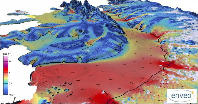
Satellites, Study Track Antarctic Ice Loss
More than two decades of observations by five radar satellites show the acceleration of ice loss of 30 glaciers in Western Palmer Land in the southwest Antarctic Peninsula.
Teledyne Optech Holding Free Workshop at GEO Business UK
May 9, 2017 — Teledyne Optech is pleased to announce that it is displaying its latest airborne and terrestrial lidar solutions for acquiring accurate geospatial data at GEO Business 2017 in London on 23-24 May 2017, and is holding a workshop on survey efficiency...
Unmissable Conference Line-Up Featuring Keynote Presentations from HS2's Sadie Morgan, Ordnance Survey's CEO Nigel Clifford, & ESRI’s Charles Kennelly
Leading organisations from across the geospatial industry, including Ordnance Survey, Google, HS2, Department of Transport, ARUP, ESRI, AGI, and the RICS, will feature prominently in GEO Business’ 2017 Conference programme. Returning to the Business Design Centre in...
World's Largest Satellite Fleet Owner Joins The Geological Remote Sensing Group
The Geological Remote Sensing Group (GRSG) has expanded its membership once again with the recent news that Planet; the owners and operators of the world’s largest commercially-operated fleet of satellites, has joined as the Group’s latest corporate member.  ...
