In a few weeks, this year’s GI_Forum will open its doors again for the 11th time. Organizer:          University of Salzburg – Z_GIS and Austrian Academy of Sciences Dates:                  Tuesday, July 4 – Friday, July 7,...
Marine Corps Systems Command Receives Award for Emergency Response System from Hexagon Safety & Infrastructure
Huntsville, Alabama – Hexagon Safety & Infrastructure presented Marine Corps Systems Command (MCSC) with an Icon Award for its efforts to improve emergency response capabilities at U.S. Marine Corps bases globally. Announced at HxGN LIVE, Hexagon’s annual...
Leidos Launches Managed Detection and Response Service, Provides Clients with Early Detection and Proactive Response for Incident Prevention
RESTON, Va. - Leidos Cyber, Inc. today announced the availability of its Managed Detection and Response (MDR) service that goes beyond traditional Managed Security Service Providers (MSSP) or Incident Response (IR) services. MDR is a continuous, end-to-end service...
Kratos to Unveil Newest High Performance Class of Military Unmanned Aerial System Technology at 2017 Paris Air Show
SAN DIEGO - Kratos Defense & Security Solutions, Inc. (NASDAQ:KTOS), a leading National Security Solutions provider, today announced the company will officially unveil a new class of unmanned aerial systems that represent the future of air combat at the 2017 Paris...
Blue Marble to Conduct LiDAR Workshop and User Group Meeting in Conjunction with the Esri UC in San Diego
Hallowell, Maine – Blue Marble Geographics (www.bluemarblegeo.com) is pleased to announce that it will be hosting two events in San Diego during the week of the annual Esri User Conference. The latest stop in the 2017 Blue Marble User Conference (BMUC) series will...
Hexagon Kicks Off HxGN LIVE Conference in Las Vegas
NACKA STRAND, Sweden: Hexagon, a leading global provider of information technology solutions, kicks off its annual HxGN LIVE event today. Running 13-16 June at The Venetian hotel in Las Vegas, NV, USA, this four-day international conference brings together thousands...
Quanergy to Demonstrate Groundbreaking LiDAR-Equipped Security Surveillance System at IFSEC
SUNNYVALE, Calif.– Quanergy Systems Inc., the leading provider of LiDAR sensors and smart sensing solutions, today announced that it will demonstrate a first-of-its-kind security solution for intruder detection and surveillance automation at IFSEC International,...
Luciad's New Cloud Server Product Puts Geospatial Data in The Hands of End Users
Leuven, Belgium - Luciad, a world leader in high performance geospatial applications, is proud to announce its new V2017 product suite aimed at users of geospatial data. The new product suite is a series of applications that will allow end users to analyze any stream...
Dynamic Cartography Moves Maps into the Future
One of the most important tools for success when the military plans missions is accurate, up-to-date geospatial information. Precise and timely information of this kind can mean the difference between sending warfighters into the field with a sound plan, or into one...
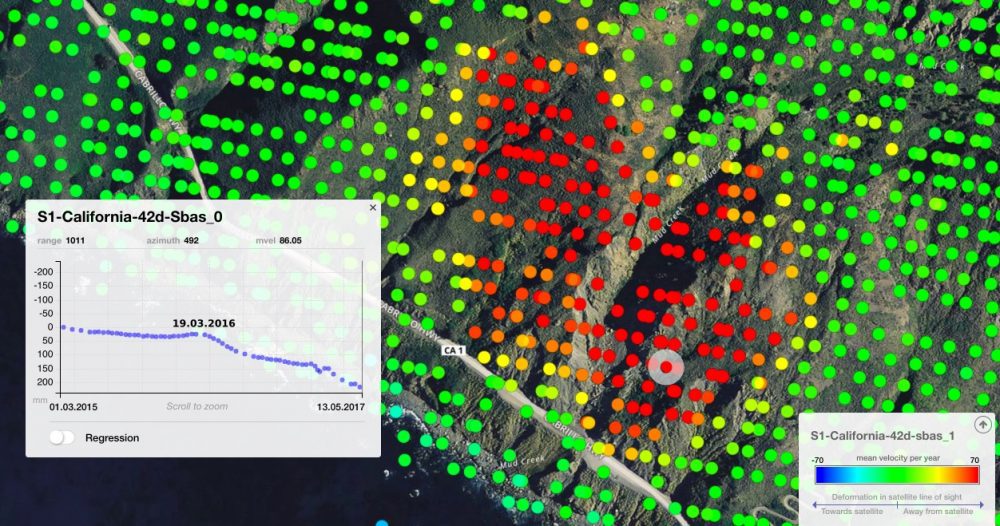
Pre-Landslide Movements Found on Radar
On May 20, 2017, more than a million tons of dirt and rock buried part of California's Highway 1 along the Pacific coastline in the state's Big Sur region. In addition to cutting off the route, the landslide added some 12 acres of land to the shoreline.
