Orbit GT has been selected to feature in the list of 20 most promising geospatial and GIS companies for 2017.  The top 20 list has been put together by CIOReview, a magazine that performs market research on a yearly basis. “We are honored and grateful to be...
University of North Alabama Online GIS Anaylst Certificate Program
University of North Alabama Offers Online GIS Analyst Certificate Program - This certificate program consists of six courses which can be completed within one year. Introduction to ArcGIS I: GIS Fundamentals(September 7 – October 3, 2017)     Introduction to...
Explore the World's Geology with Getech's Interactive Maps
Getech, providers of natural resources exploration data and information expertise, has created two interactive ArcGIS Online maps that allow users to explore an increadible amount of geological information for any region across the globe. The first of the maps allows...
DigitalGlobe Shareowners Approve Merger with MDA
WESTMINSTER, Colo. - DigitalGlobe, Inc. (“DigitalGlobeâ€) (NYSE: DGI), the global leader in Earth imagery and information about our changing planet, today announced its preliminary results that its shareowners overwhelmingly voted to approve the Company’s...
GeoCue Announces GNSS Direct GeoPositioning System For Low Cost DJI Drones
Huntsville, AL – GeoCue Group Inc. (GeoCue) is excited to announce a new GNSS positioning system that will allow users of DJI Phantom 4 Pros and Inspire 2 drones (as well as most drones using higher end cameras) to achieve survey-level accuracy with a minimum of...
FARO Introduces SCENE 7.0 With Real Time, On-Site Registration
Lake Mary, FL - FARO® (NASDAQ: FARO), the world’s most trusted source for 3D measurement and imaging solutions for factory metrology, construction BIM/CIM, product design, public safety forensics, and 3D solutions, announces the availability of the FARO® SCENE 7.0...
ILMF 2018: Call for Papers Deadline is August 14!
The 18th Annual International LiDAR Mapping Forum (ILMF), taking place in Denver, Colorado, USA, February 5-7, 2018, has announced a Call for Papers and invites interested parties to submit their abstracts by August 14, 2017. ILMF is a technical conference and...
Trimble Introduces New Android Application for Field Surveying and Data Collection
SUNNYVALE, Calif.—Trimble (NASDAQ: TRMB) introduced today Trimble® Penmap® for Android™, a cloud-connected application for field surveying and high-accuracy Geographic Information System (GIS) data collection that works on mobile handhelds, smartphones and...
A&M-Corpus Christi's Conrad Blucher Institute to Provide United Nations with GIS Expertise
CORPUS CHRISTI, Texas – The Conrad Blucher Institute for Surveying and Science (CBI) at Texas A&M University-Corpus Christi has officially joined the United Nations-Global Geospatial Information Management (UN-GGIM) Academic Network. Texas A&M-Corpus Christi...
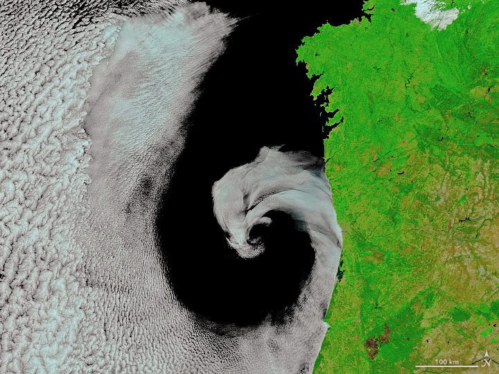
Extratropical Cyclone off Portugal
On July 16, 2017, the Moderate Resolution Imaging Spectroradiometer (MODIS) on NASA's Terra satellite captured this image of cyclonic rotation off the coast of Portugal.
