BERLIN, Sept. 26, 2017—Trimble (NASDAQ: TRMB) introduced today three new GNSS-Inertial Systems for Direct Georeferencing on Unmanned Aerial Vehicles (UAVs):  the Trimble® APX-15-EI UAV, Trimble APX-18 UAV, and Trimble APX-20 UAV. Direct Georeferencing with the...
Trimble GNSS Smart Target Base Station Provides Simplified Map Production from UAVs
BERLIN, Sept. 26, 2017—Trimble (NASDAQ: TRMB) announced today the release of the Trimble® GNSS Smart Target Base Station for high-accuracy mapping from Unmanned Aerial Vehicles (UAVs).  The announcement was made today at INTERGEO 2017, the world’s largest...
Commercial UAV Expo Europe Moves to Amsterdam in April, 2018
Portland, Maine, USA – The organizers of Commercial UAV Expo Europe, the pan-European exhibition and conference focused on UAS integration and operation for large enterprise industrial applications, announced that the 2018 event will be held 10-12 April 2018 at the...
FSC Gathers Global Forestry Leaders to Plan Future of Responsible Forest Management
Bonn –The world’s leading forest certification organization, the Forest Stewardship Council (FSC), will hold its triennial global General Assembly in Vancouver, Canada from 8 to 13 October, 2017. Over 800 people from more than 80 countries, including leaders in...
TerraGo to Showcase Mobile Geospatial Solutions at INTERGEO 2017
Washington, D.C.: TerraGo, a pioneer of geospatial collaboration and mobility software, will exhibit at INTERGEO 2017, which takes place September 26th – 28th in Berlin, Germany.    “INTERGEO brings together the global leaders of the industry and creates an...
YellowScan and Quantum Systems Partner to Provide a Cutting Edge VTOL+LiDAR System
YellowScan and Quantum Systems combined their R&D expertise to provide a reliable VTOL+LiDAR solution, able to cover large areas and fly longer (up to 60 minutes) for a high quality data acquisition. The YellowScan Surveyor LiDAR and the Quantum Tron VTOL...
Teledyne Optech and IGI Announce New Cooperative Agreement and First Product Offering
Teledyne Optech is pleased to announce a new cooperative agreement with IGI - Integrated Geospatial Innovations, Germany, a long-time industry leader in the development, sale, deployment and service of advanced remote sensing technologies within Europe and abroad....
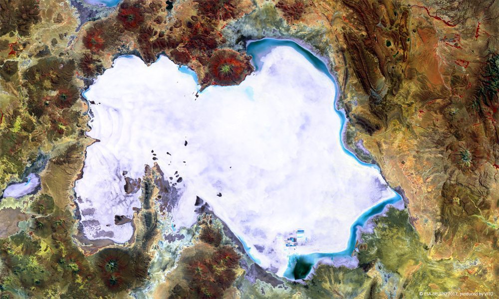
World's Largest Salt Plain Seen from Space
Covering 10,500 square kilometers, Bolivia's Salar de Uyuni is the world's largest salt plain.
Severn Trent Water Trials Rezatec's Innovative Geospatial Data Analytics to Monitor Asset Risk and Detect Pipeline Leakage
Harwell, Oxfordshire: Severn Trent Water are now trialling Rezatec’s unique and pioneering asset risk monitoring and pipeline leakage detection data products with a view to reducing their costs and improving operational efficiency. The satellite-powered geospatial...
Ordnance Survey to Support Singapore with its Status as a Smart Technology World Leader
Ordnance Survey International (OSI) has been contracted to support project lead the National University of Singapore and the Singapore Government with its continued vision to be a Smart Technology world leader. The two-year project will address the automation...
