JACKSONVILLE, FL - Drone Aviation Holding Corp. (OTCQB: DRNE) (“Drone Aviation†or the “Companyâ€), a manufacturer of tethered drones and lighter-than-air aerostats, today announced that it has received an order for its recently upgraded, multi-mission capable...
Mapbox Releases New Map to Track Fires in Northern California and Across the U.S.
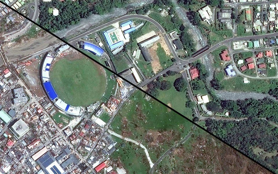
SAN FRANCISCO - Mapbox has published a new map to give people affected by the wildfires in Northern California and across the U.S. access to the most up to date information on fire perimeters in relation to specific locations and addresses. Using the best available...
Global Mapper and LiDAR Module SDK v19 Released with Expanded Online Data Support and Improved LiDAR Ground Point Detection and Reclassification
Hallowell, Maine - Blue Marble Geographics (www.bluemarblegeo.com) is pleased to announce the immediate availability of version 19 of the Global Mapper Software Development Kit (SDK) along with the accompanying LiDAR Module SDK. Released in conjunction with the...
Esri Silver Business Partner, GEO Jobe, Participation at the 5th Annual Mississippi Geospatial Conference
GULFPORT, Miss. - GEO Jobe to Share "The Power of GIS, Simplified" at the 2017 Mississippi Geospatial Conference GEO Jobe is pleased to be involved as a supporter and sponsor of the 5th annual Mississippi Geospatial Conference, taking place October 19-20, 2017 at the...
Phase One Industrial and Lufthansa Aerial Services Sign Cooperation Agreement for UAV-based Aerial Imaging
COPENHAGEN and FRANKFURT, Oct. 18, 2017 ― Phase One Industrial and Lufthansa Aerial Services announced that they have signed an agreement to explore collaborative development and deployment of unmanned aerial vehicles (UAVs) for a range of specialized industrial...
Virtual Surveyor Unveils Productivity Tools in Drone Image Analysis Software at Commercial UAV Expo
LEUVEN, Belgium, 18 October 2017 – Virtual Surveyor nv, developer of UAV image visualization and analysis software, will launch a new suite of Productivity Tools next week at the 2017 Commercial UAV Expo in Las Vegas. The Virtual Surveyor software package enables...
Seiler Instrument, Inc. Selects Microdrones mdMapper Packages to Serve the Midwest U.S.
ST. LOUIS - Trimble Dealer Seiler Instrument & Mfg. Co., Inc., offers advanced, integrated tools for geospatial professionals in the Midwest U.S. With more than 72 years of successful sales and service, Seiler Instrument has built its reputation on exceptional...
New Road-SIT Survey Vertical Application for the Maintenance of the Utility Tetworks with Mobile Mapping Technology
18 October, 2017, Bologna, Italy – Siteco announces the implementation of the Road-SIT Survey Software application, for the management of the maintenance and rehabilitation interventions of the utilities networks. The most immediate and frequent need for...
MDA Completes Acquisition of DigitalGlobe, Company Renamed Maxar Technologies
MacDonald, Dettwiler and Associates (MDA) completed its acquisition of DigitalGlobe. The newly combined company will offer a broader set of space-based solutions, increased scale and a more-diversified revenue base.
National Geospatial-Intelligence Agency Awards Leidos Prime Contract for Information Technology Management
RESTON, Va.- Leidos (NYSE: LDOS), a FORTUNE 500® science and technology company, was awarded a prime contract by the National Geospatial-Intelligence Agency (NGA) under the Information Technology Enterprise Management (ITEMS) User Facing Services (UFS) program. This...
