Los Angeles, CA – VRgineers introduces XTAL, a new VR headset built meticulously around the needs of professional designers and engineers who require superior image quality and accuracy, wide field-of-view, easy integration, and data security. Whether users want to...
TerraGo Releases New Version of Smart Streetlights Application Platform
TerraGo, a leading provider of mobile workforce collaboration solutions, announced today the availability of a new version of TerraGo Streetlights, a platform designed specifically for smart streetlight projects with an ever-growing list of field-tested,...
Teledyne Optech to Showcase GIS Tools at Esri 2018 User Conference
Teledyne Optech is pleased to announce that it will be exhibiting at the Esri 2018 User Conference in San Diego, CA, USA, on July 10-12. GIS professionals can learn about the latest lidar and imaging solutions for acquiring geospatial data at Booth 1927. Teledyne...
Esri Publishes Cartography
Redlands, California — Esri, the global leader in spatial analytics, today announced the publication of Cartography., a comprehensive, crisply designed compendium of information about what constitutes good map design. Written by award-winning cartographer Kenneth...
Garmin Selects KVH to Provide Marine Satellite TV Antenna Systems to Boaters Worldwide
OLATHE, Kan. and MIDDLETOWN, R.I. - Garmin® International, Inc. a unit of Garmin Ltd. (Nasdaq:GRMN), and KVH Industries, Inc., (Nasdaq:KVHI), announced an arrangement to offer two marine satellite TV antenna systems made by KVH as part of a Garmin marine network...
University of Maine Launches Concept3D Interactive Map Platform
DENVER – Concept3D, a leader in creating immersive online experiences with 3D modeling, interactive maps and virtual tour software, today announced that The University of Maine is the latest major university to launch on the Concept3D platform. The...
Juniper Unmanned Named 2018 Colorado Company to Watch Golden-Based Company Honored at 10th annual Gala Awards
DENVER, Colo. - Juniper Unmanned, Inc., a premier operator of unmanned aircraft systems (UAS) with advanced sensing technologies, was named a 2018 Colorado Company to Watch winner Friday at the 10th annual Gala Awards. The Colorado Companies to Watch award honors...
HxGN SmartNet, AZGPS Join Forces to Expand High-Precision GNSS Correction Services in the Southwestern USA
(Norcross, Ga.) – Hexagon’s Geosystems division, the complete reality capture solutions provider, today announced HxGN SmartNet, the industry-leading high-precision, high-availability GNSS network correction service, has partnered with AZGPS LLC to expand access...
International Space University Confers Honorary Doctorate Degree Upon Michael Potter
DELFT, The Netherlands, June 27, 2018 - The International Space University (ISU) announced that the Board of Trustees has conferred an Honorary Doctorate Degree to space and technology visionary and thought leader Michael Potter. Michael Potter was presented the...
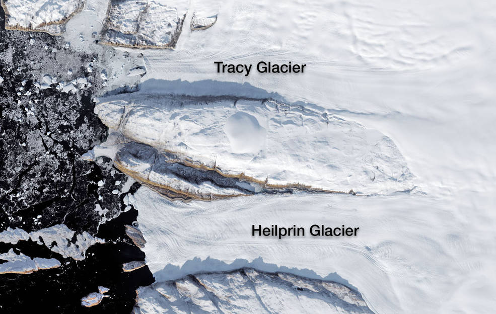
NASA Study Solves Glacier Puzzle
A new NASA study explains why the Tracy and Heilprin glaciers, which flow side by side into Inglefield Gulf in northwest Greenland, are melting at radically different rates.
