Redlands, California—Esri, the global leader in location intelligence, today announced that Survey123 for ArcGIS, Esri's smart-form-data gathering solution, will now be offered as part of Microsoft Flow's connector community. Survey123 is a go-to field data...
NSR Report: Data Applications Drive $189 Billion in Satellite Capacity Revenues over Next Decade
CAMBRIDGE, Mass. - NSR’s Global Satellite Capacity Supply & Demand, 15th Edition report, published today, finds satellite capacity revenues continue a long-range growth path of 6.8% CAGR over the next decade. However, near term caution persists as business...
13 GA-ASI Suppliers Recognized with Supplier Excellence Awards
SAN DIEGO – General Atomics Aeronautical Systems, Inc. (GA‑ASI) has honored 13 suppliers with the company’s annual Supplier Excellence Awards. The awards recognize outstanding quality and delivery performance. GA-ASI is a leading manufacturer of Remotely Piloted...
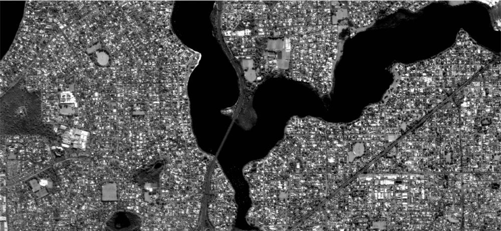
Aist-2D Satellite Sends First High-Resolution Fixed-Antenna Image
A high-resolution image of Perth, Australia, sent by Russian satellite Aist-2D was received by the LoReTT laboratory on June 15, 2018, the first time such a detailed image (two-meter spatial resolution) was sent via an antenna that doesn't have a traditional rotational device.
Rewire Security Announces a Major Software Update for GPSLive
Bristol, the United Kingdom Rewire Security, one of the leading GPS Tracking systems suppliers in the UK, announces a major update to its GPS Tracking software. GPSLive allows individuals and small businesses to keep an eye on their vehicles and assets 24/7. GPSLive...
Geomesure to Supply Microdrones mdSolutions in France
Geomesure, the official distributor of Trimble topographical equipment in the South and West of France, has announced they are now offering Microdrones UAV solutions in France. Geomesure has more than thirty years’ experience of supporting the surveying service...
Leica Geosystems, RPA Partner to Increase Efficiency in CAP Claims
Milton Keynes, UK, 24 July 2018) – Leica Geosystems, industry leader in measurement technology, today announced its plans to provide the Rural Payment Agency (RPA) with an enhanced solution for verifying claims under the European Union’s Common Agricultural...
CompassTools Sells to Frontier Precision
Centennial, Colorado - CompassTools, Inc. located in Centennial, Colorado is pleased to announce that it has sold the assets for their Trimble Geospatial Dealership to Frontier Precision, one of the largest resellers of geospatial technology in North America. Frontier...
Powerful Satellite Built by Maxar Technologies' SSL for Telesat is Performing Post-Launch Maneuvers According to Plan
PALO ALTO, Calif. – SSL, a Maxar Technologies company (formerly MacDonald, Dettwiler and Associates Ltd.) (NYSE: MAXR; TSX: MAXR), and a leading provider of innovative satellites and spacecraft systems, announced today the advanced high throughput satellite built...
Frontier Precision Announces Acquisition of Aerial Horizons UAS in Sioux Falls, SD
Aerial Horizons has established themselves over the past couple of years as a leading provider of UAS solutions, with an emphasis on the Public Safety sector and specifically with DJI products as a DJI Enterprise dealer. We look forward to having their expertise,...
