DENVER – Concept3D, a leader in creating immersive online experiences with 3D modeling, interactive maps and virtual tour software, today announced that The University of Tennessee, Knoxville is the latest major university to launch on the Concept3D platform. ...
Esri Enters into Memorandum of Understanding with World Bank
Redlands, California—Esri, the global leader in location intelligence, today announced that it has entered into a memorandum of understanding (MOU) with the World Bank, an international organization with the mission to reduce global poverty. Under the agreement,...
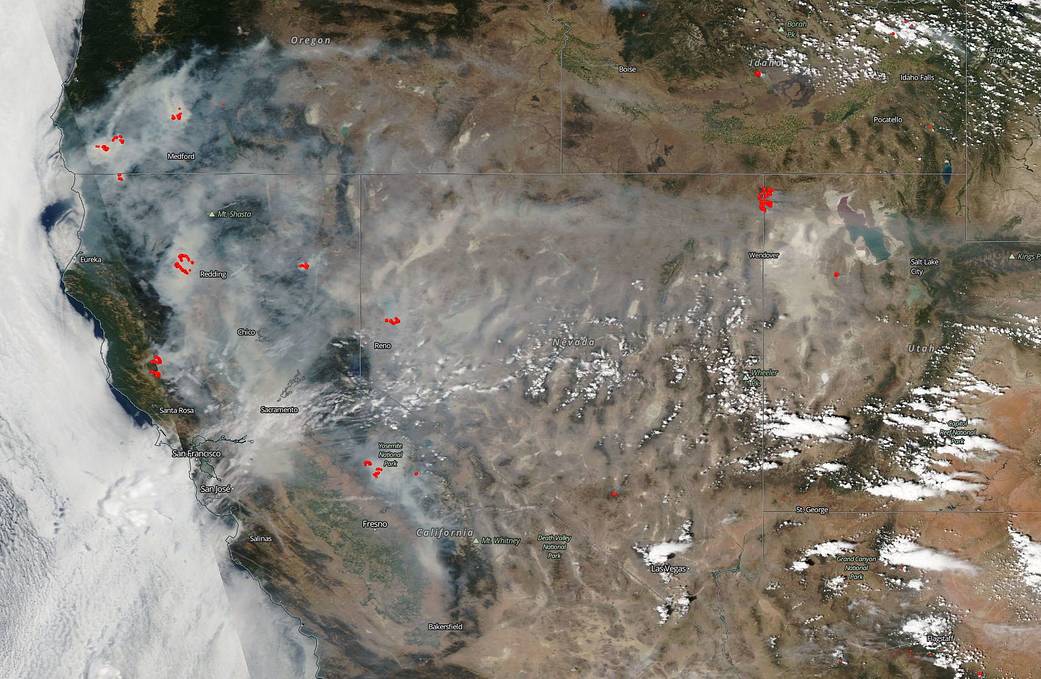
NASA Satellite Shows California Shrouded in Smoke
On July 29, 2018, NASA's Aqua satellite captured this natural-color image of the fires in California and the resultant smoke that has shrouded the state and swept eastward as far as Salt Lake City and still moving.
Copernicus Accelerator is Looking for High-level Professionals as Mentors: Call for Experienced Mentors
The 2018 Copernicus Accelerator, Europe’s Earth observation (EO) business coaching programme, is looking for mentors to pass on their knowledge and experience to 50 entrepreneurs and start-ups. Registrations are possible until 17.09.2018 at accelerator.copernicus.eu...
ARC Research Indicates Geographic Information Systems are Moving to the Cloud
DEDHAM, Mass.- New ARC Advisory Group research on the geographic information system (GIS) market reveals that GIS technology, which was once considered highly specialized, is now moving into the realm of mainstream information technology (IT). One indicator of this...
Sphere Drones to Offer Microdrones UAV Solutions
Rome, NY - Sphere Drones, a leading Australian provider of drone solutions for commercial applications, will become the newest distributor of Microdrones fully-integrated systems. Darren Wilkinson, Sales Manager for Microdrones, explains “Sphere Drones is trusted...
Thales Alenia Space and Maxar Technologies' SSL Form Consortium to Further Design and Develop Telesat's LEO Satellite Constellation
CANNES, France and WESTMINSTER, Colo. - July 30, 2018 - Thales Alenia Space, a Joint Venture between Thales (67 %) and Leonardo (33 %), and SSL, a Maxar Technologies company (NYSE: MAXR; TSX: MAXR), have signed a consortium agreement to pursue the development and...
Geotab Launches data.geotab.com, a New Tool to Help Enable Smart Cities
Toronto, ON – Geotab, a global leader in IoT and connected transportation, today announced the launch of its new website, data.geotab.com. Aiming to empower organizations and municipalities in the development of smart cities, data.geotab.com grants public access to...
SuperGIS Desktop Will Further Support MariaDB in the Next Update
As there are lots of advantages of using open source resources and its convenience in use, open source resources have recently become all the rage in the technology field. Following this major trend, Supergeo has done much research on open source resources as well as...
Maxar Technologies’ MDA appoints Michael Rack President, MDA Commercial to Lead Space Systems Product Growth in the New Space Economy
BRAMPTON, ON - MDA, a Maxar Technologies company (formerly MacDonald, Dettwiler and Associates Ltd.), (NYSE: MAXR) (TSX: MAXR), today announced the appointment of Michael Rack to serve as President of the newly-created MDA Commercial division beginning September 24,...
