New U.S. Geological Survey 5-meter Interferometric Synthethic Aperture Radar data suggest North America's tallest peak may be 83 feet shorter than previously thought.
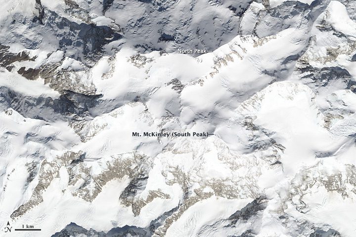
New U.S. Geological Survey 5-meter Interferometric Synthethic Aperture Radar data suggest North America's tallest peak may be 83 feet shorter than previously thought.
Governors of Maryland, New Jersey and Virginia are supporting efforts by three universities in their respective states to partner on a Federal Aviation Administration drone test site.
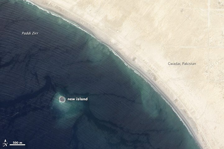
On Sept. 24, 2013, a 7.7-magnitude earthquake rattled western Pakistan, leaving at least 350 people dead and than 100,000 homeless. The quake also created a new island near Gwadar, Pakistan.
A September 2013 Department of Justice report reveals the agency has spent $3.7 million on small drones since 2006, including $3 million for the Federal Bureau of Investigation.
MANASSAS, Va., Sept. 17, 2013—Aurora Flight Sciences announced today at the Air Force Association Air and Space Conference that the Orion Unmanned Aerial System (UAS) successfully completed its first flight on August 24, 2013. The flight was conducted on a western...
Hallowell, Maine, Sept. 18, 2013—Blue Marble Geographics (bluemarblegeo.com) is pleased to announce the release of Global Mapper version 15. This major release includes many powerful updates along with a new extension interface that provides add-on functionality...
Berlin, Germany, Sept. 18, 2013—RapidEye, a global leader in high-resolution wide-area satellite coverage, is proud to announce their contribution to Esri’s ArcGIS online platform. Users will now have access to RapidEye’s newly launched premium content services...
Ramat Gan, Israel, Sept. 17, 2013—VisionMap and TopoFlight Systems are pleased to announce the full compatibility of TopoFlight 3D flight planning software with VisionMap’s A3 Digital Mapping Systems, including the new A3 Edge system. VisionMap’s integration...
MANASSAS, Va., Sept. 18, 2013—Aurora Flight Sciences announced today that The Honorable Ellen O'Kane Tauscher has been elected to the Aurora Board of Directors. Tauscher is a former Member of the United States House of Representatives, representing California's 10th...
Nairobi, Kenya, Sept. 18, 2013—An environmental scientist and entrepreneur who revolutionized the use of geo-spatial technology for conservation is to receive the 2013 Champions of the Earth Award, the UN’s highest environmental accolade. Jack Dangermond – who...
