Des Plaines, Ill., Dec. 10, 2013—URISA is now accepting presentation proposals for GIS-Pro 2014: URISA's 52nd Annual Conference to be held in New Orleans, Louisiana, September 8-11, 2014. The focus of GIS-Pro 2014 is “Leveraging Spatial Technology to Support...
Altus Becomes a Member of Esri Partner Network
Torrance, Calif., Dec. 5, 2013—Altus Positioning Systems is now a member of the Esri Partner Network, the global community of companies developing and selling geographic information systems (GIS) using the ArcGIS platform. The Esri Partner Network is comprised of...
Effigis, Astrium Sign Agreement for Exclusive Distribution of Pléiades Satellite Images in Canada
Dec. 5, 2013, Montreal, QC, Canada—Effigis Geo-Solutions Inc., a leading distributor of Earth observation images, is pleased to announce it has signed an exclusive agreement to distribute satellite images from the Pléiades satellites operated by Astrium Services, a...
Mississippi's Geospatial Cluster Continues Growth with Six New Members
Stennis Space Center, Miss., Dec. 4, 2013—The Enterprise for Innovative Geospatial Solutions (EIGS) is pleased to announce the addition of six new members to Mississippi’s geospatial technology industry cluster. Adcentives.net Adcentives, headquartered in New...
Natural Resources Canada Selects Compusult’s Web Enterprise Suite to Implement the Earth Observation Data Management System
Mount Pearl, NL, Canada, Nov. 26, 2013—Recognized internationally for its advanced, standards-based geospatial data management solutions, Compusult Limited is pleased to announce it has been selected by Natural Resources Canada (NRCan), through the Canada Center...
Rhodes Communications Celebrates 30 Years of Business
NORFOLK, Va., Nov. 26, 2013—Rhodes Communications, Inc., an international public relations and marketing services company based in Norfolk, Va., celebrates its 30th year of business this month. Founded in 1983 by Jim Rhodes, the company originally focused primarily...
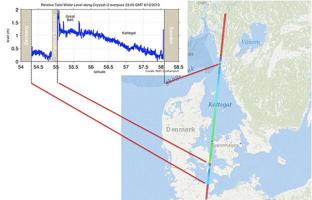
Cryosat Measures European Storm Surge
The European Space Agency's CryoSat satellite measured the storm surge from the recent North Sea storms, as high waters passed through the Kattegat Sea between Denmark and Sweden.
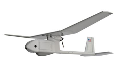
Ohio Conducts Airspace Study to Fly Unmanned Aircraft Systems
A study set to be completed early next year will lead to developing a unique national capability in Ohio for flying unmanned aircraft systems.
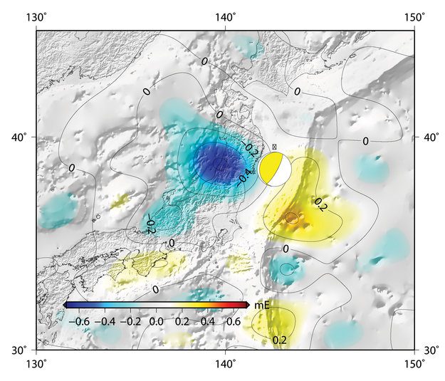
Earth's Gravity Scarred by Earthquake
The European Space Agency's GOCE satellite has revealed that the devastating 2011 Japanese earthquake left its mark in Earth's gravity”another example of the extraordinary mission surpassing its original scope.
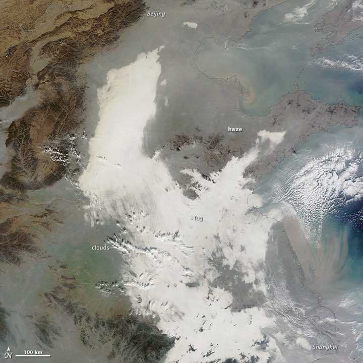
China Hit by Severe Smog”Again
China suffered another severe bout of air pollution in December 2013. Thick haze stretched from Beijing to Shanghai, a distance of about 1,200 kilometers (750 miles).
