A massive engineering project aims to temporarily separate the Venetian Lagoon from the Adriatic Sea when unusually high tides occur through a series of 78 gates that seal the lagoon's three inlets.
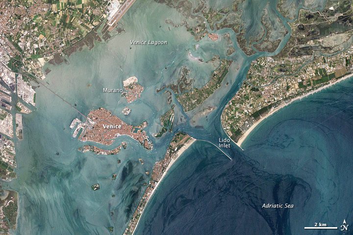
A massive engineering project aims to temporarily separate the Venetian Lagoon from the Adriatic Sea when unusually high tides occur through a series of 78 gates that seal the lagoon's three inlets.

Twenty years of radar coverage from European Space Agency satellites have been used to measure the rapid thinning of Antarctica's Pine Island Glacier, and it's losing more ice than previously thought.

NASA and the Japan Aerospace Exploration Agency released the first images from their new Earth-observing satellite, the Global Precipitation Measurement Core Observatory.
Irvine, Calif., March 19, 2014—2d3 Inc. (dba 2d3 Sensing) announced the launch of a new version of Reticle Georegistration. This enhancement is part of the latest release of its motion imagery processing, exploitation, and dissemination product suite: TacitView™...
FLAGLER BEACH, Fla., March 21, 2014—The VrAirTrig package simplifies the accurate collection, editing and management of aerial triangulation data. A project management tool helps manage large jobs with the speed and flexibility needed for maximum efficiency in...
Redlands, Calif., March 18, 2014—Esri has released new versions of Collector for ArcGIS and Operations Dashboard for ArcGIS. The Collector app now includes the ability to download maps to your smartphone or tablet device to collect and edit data when working...
Fitchburg, Mass., March 20, 2014—Headwall Photonics announced the introduction of the Hyperspec SNAPSHOT imaging sensor which has been designed for commercial use by environmental researchers, civil engineers, and remote sensing organizations. The Hyperspec®...
Lausanne, Switzerland, March 20, 2014—WaldoAir and Pix4D announce the launch of the first integrated camera system for use on single engine aircrafts bundled with aerial image processing software. This complete system offers the manned aircraft industry the same...
Houston, March 20, 2014—At the ASPRS 2014 Annual Conference in Louisville next week, Visual Intelligence will unveil iOne Oblique Analytix™, a software solution that unlocks the potential of oblique imagery by enabling geospatial companies to view, analyze,...
Hallowell, Maine, April 18, 2014—Blue Marble Geographics (www.bluemarblegeo.com) will be conducting a workshop at the forthcoming AAG (Association of American Geographers) Annual Meeting in Tampa, Florida. The workshop, entitled “LiDAR Processing and Terrain...
