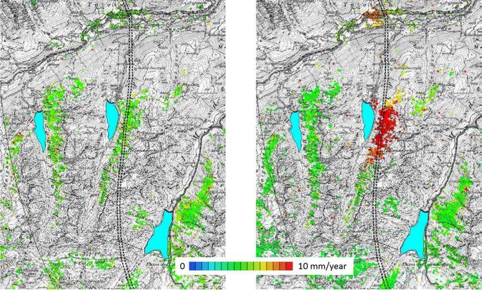
As shown by the March 2014 Oso, Wash., mudslide that killed 41 people, subsidence, rockfalls and landslides can cause devastating human and economic consequences. But satellites can help.
As shown by the March 2014 Oso, Wash., mudslide that killed 41 people, subsidence, rockfalls and landslides can cause devastating human and economic consequences. But satellites can help.

The Oregon Forestry Department is building a helicopter unmanned aircraft system (UAS) to get into small, smoky places that are inaccessible or too dangerous for humans.
June 11, 2014—A new netCDF Standards Working Group (SWG) is being chartered to further extend the existing netCDF standard with extension modules for additional data models, encodings, and conventions. Initiators of the new SWG seek comments from the public on the...
June 12, 2014—The Open Geospatial Consortium (OGC™) membership seeks public comment on the candidate OGC Web Map Tile Service Simple Profile of the OGC Web Map Tile Service (WMTS) Interface Standard. Current OGC WMTS Interface Standard implementations return...
FORT COLLINS, Colo., June 11, 2014—Red Hen Systems' MediaMapper Mobile is the only Android app that lets you snap a photo, record a video, make an audio note, and collect project data, while automatically geotagging it. The result? You can display the geotagged...
SUNNYVALE, Calif., June 12, 2014—Trimble (NASDAQ: TRMB) introduced today a new version of its powerful office software suite used by surveyors and geospatial professionals for processing and analyzing geospatial data—Trimble® Business Center. Version 3.21...
Herndon, Va., June 4, 2014—The U.S. Geospatial Intelligence Foundation’s newly released monograph, “Human Geography: Socio-Cultural Dynamics and Global Security,†is now available for purchase via the USGIF website or Amazon.com. The volume is the first...
Anchorage, Alaska, June 12, 2014—DAT/EM Systems International® welcomes Dr. Zhijun (Jeff) Wang as Photogrammetric Software Engineer. He joins DAT/EM from Quebec City, Canada where he completed his post-doctoral degree in Geomatics from the University of Sherbrook...
Madison, Ala., June 11, 2014—Join us for a 3-day LP360 training session September 23-25, 2014 in Huntsville, Ala. The three day session will begin with an in-depth look at using LP360 for QA/QC of LIDAR data and then focus on the standard and advanced levels of the...
Reston, Va., June 13, 2014—MAPPS, the national trade association for private sector geospatial firms, today announced it will host a special webinar to discuss the process to apply with the Federal Aviation Administration for an exemption for commercial use of...
