June 19, 2014—The Open Geospatial Consortium (OGC®) and the European Commission's Joint Research Centre (JRC) have signed a collaboration agreement to enhance the development and use of geospatial standards. It is anticipated that this collaboration will enable the...
Scene Sharp USA Signs Flex Analytics as First Fuze Go Distributor
CLEVELAND, June 18, 2014—Scene Sharp™ USA has signed Flex Analytics as the first distributor of its Fuze Go™ universal image fusion software technology. The distribution agreement allows Flex Analytics to sell the Fuze Go MS Sharp and Fuze Go SAR Sharp software...
Seattle City Light Deploys TerraGo's GeoPDF to Bring Portable, Interactive Maps to Field Workers
Washington, D.C., June 17, 2014—Seattle City Light, the 10th largest U.S. public electricity company, has implemented TerraGo’s GeoPDF® products to improve field service technology and operations. With over 1,800 employees and a large percentage deployed as...
SSTL Announces the Successful Launch of KazEOSat-2
GUILDFORD, United Kingdom, June 20, 2014—SurreySatellite TechnologyLtd (SSTL) todayannounced the successful launchofKazEOSat-2,amediumresolution Earth observation satellite for theRepublic ofKazakhstan, atUTC 19:11:1.Thespacecraftwaslaunched intoa630km...
URISA 2014 Salary Survey Data Collection Period Opens
Des Plaines, Ill., June 17, 2014—The entire GIS community is asked to help develop an important profile of GIS professional activities and compensation by participating in the 2014 URISA GIS Salary Survey. URISA conducts a periodic comprehensive Salary Survey for...
VisionMap and Acute3D Announce Sale of 3-D Modeling Solution
Ramat Gan, Israel, June 16, 2014—VisionMap Ltd and Acute3D announced today the first sale of their joint 3D modeling solution to the Tianjin institute of Survey & Mapping. The bundle solution combines VisionMap’s A3 Airborne Digital Mapping System and...
U.S. Army Awards Contract to Raven Industries for Vista Smart Sensor Radar Systems
ARLINGTON, Va., June 18, 2014—Vista Research, a subsidiary of Raven Aerostar (Nasdaq:RAVN), has been awarded an operations and maintenance contract for the upgrade and replacement of currently-fielded radar systems in support of the U.S. Army's Persistent Ground...
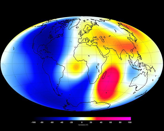
ESA Satellites Unveil Earth's Latest Magnetic Changes
The first set of high-resolution results from the European Space Agency's three-satellite Swarm constellation reveals the most recent changes in the magnetic field that protects our planet.
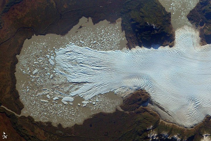
Chilean Glaciers Losing Ground
Chile's Northern Patagonian ice field is one of the world's largest temperate ice fields, but photos from space show its glaciers appear to be losing a significant amount of mass.
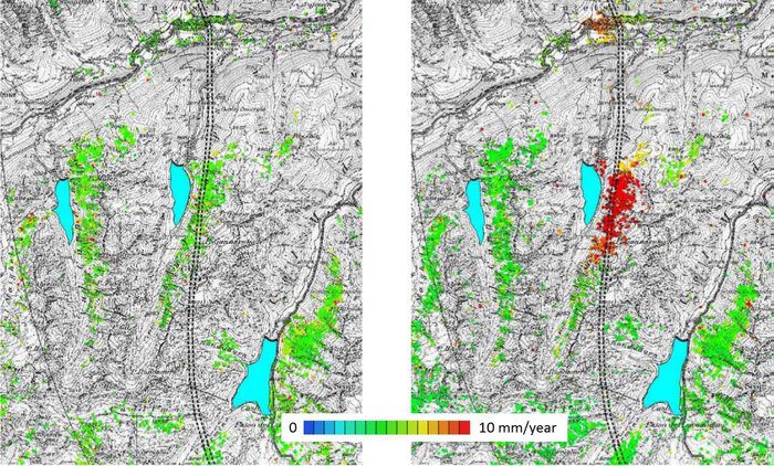
Satellites Can Detect Shifting Land, Save Lives
As shown by the March 2014 Oso, Wash., mudslide that killed 41 people, subsidence, rockfalls and landslides can cause devastating human and economic consequences. But satellites can help.
