Beachwood, Ohio-based Tremco Roofing partnered with Toronto-based Industrial SkyWorks to use drones equipped with infrared and video cameras to find energy leaks for customers in Canada.
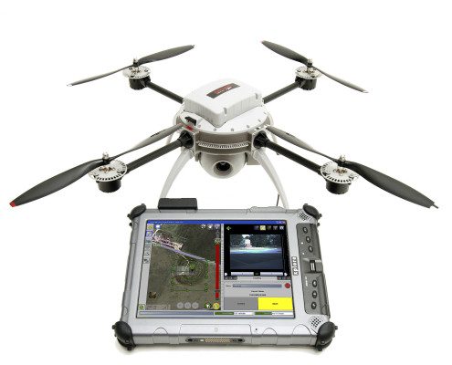
Beachwood, Ohio-based Tremco Roofing partnered with Toronto-based Industrial SkyWorks to use drones equipped with infrared and video cameras to find energy leaks for customers in Canada.
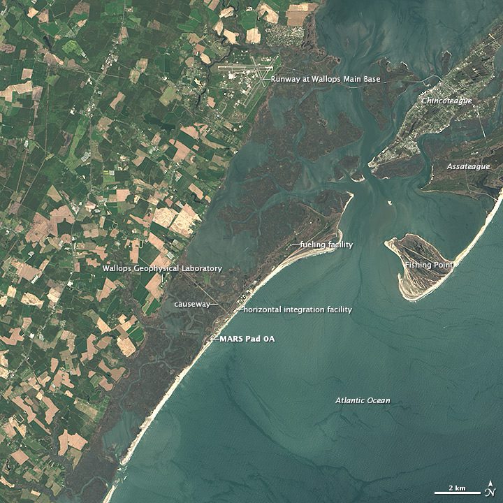
Where wild ponies once roamed the marshes and beaches, today Wallops Island is the site of a thriving spaceport that launches several commercial and government rockets each year.
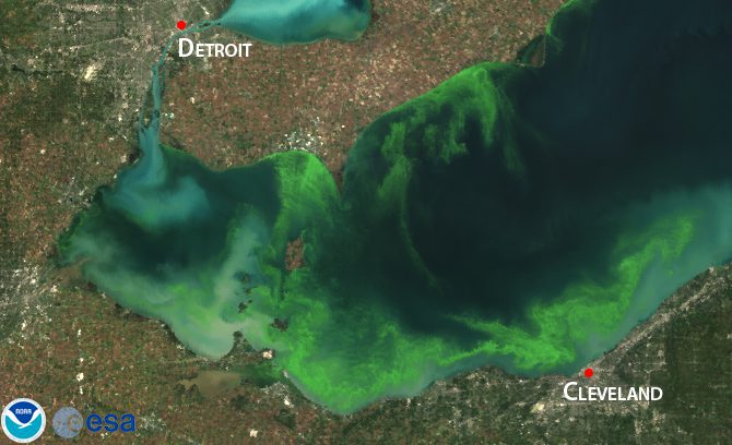
The National Oceanic and Atmospheric Administration and its research partners predict a significant bloom of cyanobacteria, a toxic blue-green algae, for Lake Erie later this summer.
While European Space Agency engineers have almost finished building the first Sentinel-3 satellite for ocean forecasting, a beer cooler has an unusual role in supporting the mission.
MADRID, July 3, 2014—DEIMOS-2, Spain's first ultra-high resolution satellite launched into orbit on 19 June, has started capturing its first images just 12 hours after it was brought on line. To view the Multimedia News Release, please click:...
PARIS, June 27, 2014—A Harfang unmanned aircraft system (UAS) belonging to the French Air Force (FAF) controlled by a crew from the French Military Flight Test Centre (Centre d'Expérience Aérienne Militaire), the UAS Squadron “Belfort†(ED 1/33) and the UAS...
Redlands, Calif., July 1, 2014—Two of the nation’s most authoritative mapping sources, the U.S. Geological Survey and Esri, have partnered to put the rich tapestry of U.S. Historical Maps into the hands of everyone. Available in time for the Fourth of July and...
July 1, 2014—The Open Geospatial Consortium (OGC®) membership has approved the Open Modelling Interface Standard Version 2 (OpenMI) as an OGC standard. This standard defines a means by which independently developed computer models of environmental processes, or...
June 26, 2014—22 public Engineering Reports resulted from the Open Geospatial Consortium's (OGC®) recently completed OGC Interoperability Testbed 10 (OSW-10), the most recent in the OGC's yearly series of major geospatial interoperability testbeds. Eight of these...
AURORA, Colo., June 30, 2014-American Sentinel University, an accredited online university that offers degree programs focused on the needs of high-growth careers, will be exhibiting its innovative competency-based geographic information systems (GIS) degree programs...
