Aug. 13, 2014—At the recent OGC meetings in Geneva, members of the OGC formed an OGC Big Data Domain Working Group. This OGC domain group provides an open forum for discussions and standards recommendations for Big Data interoperability, access, and analytics...
PT. Karvak Nusa Geomatika Selects Optech Orion ALTM for Mapping Asia Pacific
TORONTO, Aug. 13, 2014—Optech is pleased to announce the commissioning of a second high-precision Optech airborne sensor for PT. Karvak Nusa Geomatika this week in Jakarta, Indonesia. The Optech Orion M sensor joins the Optech Gemini that PT. Karvak has been...
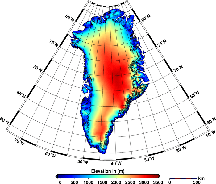
Measuring Ice Sheet Highs, Lows and Loss
New results from the European Space Agency's CryoSat mission reveal combined ice volume loss at an unprecedented rate of 500 cubic kilometers a year.

New Satellite Data to Help Farmers Facing Drought
With no ground- or satellite-based global network monitoring soil moisture at a local level, farmers eagerly await NASA's Soil Moisture Active Passive satellite.
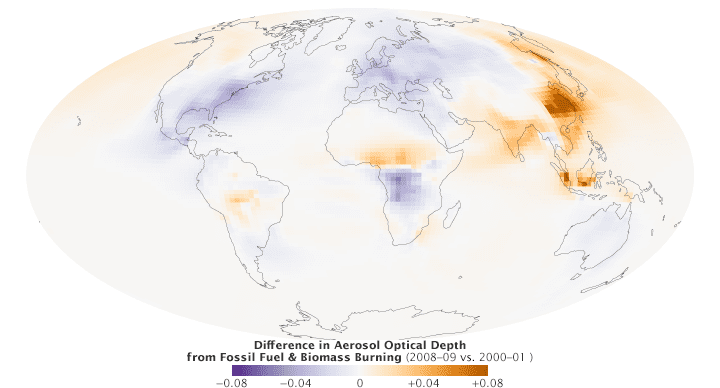
Satellites Trace Changes in Air Pollution
Air pollution is one of the world's greatest environmental health risks. So how does exposure to air pollution vary around the world and how has it changed over time?

China Uses Drone for Earthquake Response
In early August, for the first time in China, an unmanned aircraft system was used to rapidly model the aftermath of an earthquake at Longtoushan, the quake's epicenter.
Blue Marble Announces GeoCalc Fully Managed Version 7.0 with Flexible Options for Streamlining the Development Process
Hallowell, Maine, Aug. 12, 2014—Blue Marble Geographics (bluemarblegeo.com) is pleased to announce the release of GeoCalc 7.0 in a fully managed .NET version. This release features a new polygon “Area of Use†extension to the datasource, updated US NGS's VDatum...
LandWorks Enhances Web AutoMapper Service to Include WhiteStar Grid
HOUSTON, Aug. 6, 2014—LandWorks Inc., a developer of innovative land management solutions, has enhanced its Web AutoMapper online service that converts land legal descriptions into GIS-ready map polygons. Clients can now have their property polygons displayed on the...
Latest Arkansas and South Carolina Quads Available
Reston, Va., Aug. 6, 2014—New US Topo maps for Arkansas (874 maps) and South Carolina (519 maps) have been posted to the USGS Map Locator & Downloader and are also accessible through The National Map viewer. The revised maps feature a new design that was...
OGC Publishes Testbed 10 Open Mobility Location Standards Engineering Reports
Aug. 7, 2014—Nineteen public Engineering Reports resulted from the Open Geospatial Consortium's (OGC®) OGC Testbed 10, the most recent in the OGC's yearly series of major geospatial interoperability testbeds. Six of these reports focused on Open Mobility, that is,...
