RICHMOND HILL, Ontario, Canada, Aug. 27, 2014—PCI Geomatics, a world leading developer of remote sensing and photogrammetric software and systems, announced today a series of online and live events focused on the Geomatica 2014 software release. The Geomatica 2014...
URISA Announces GIS-Pro 2014 Virtual Conference Agenda
Des Plaines, Ill., Aug. 28, 2014—GIS-Pro 2014: URISA’s 52nd Annual Conference is taking place September 8-11 in New Orleans, Louisiana. For those unable to travel to the conference due to budget or time constraints, there is a unique opportunity to participate...
Young GIS Practitioners Encouraged to Apply to URISA Vanguard Cabinet
Des Plaines, Ill., Aug. 29, 2014—URISA is pleased to announce the availability of the 2015 Vanguard Cabinet application. The Vanguard Cabinet (VC) is a URISA initiative which debuted in 2011 to engage young GIS practitioners (35 and under), increase their numbers in...
DMCii Invests for the Future
GUILDFORD, United Kingdom, Aug. 28, 2014—DMC International Imaging (DMCii), the global satellite imagery products and services provider, have made major improvements to their data centre, involving a full internal upgrade of processing systems. Over five billion sq....
Estimates of the Value of the UAV Market Vary Widely
AMSTERDAM, Sept. 2, 2014—Unmanned aerial vehicles (UAVs), drones, remotely piloted vehicles. Intriguing yet sometimes controversial. No form of technology has provided as much fascination since man first undertook powered flight. Recent years has seen an increase in...
Unmanned Aircraft Partnership Reaches Major Milestone
WARSAW, Poland, Aug. 29, 2014—A team of research students and staff from Warsaw University of Technology have successfully demonstrated the first phase of flight test and integration of unmanned aircraft platforms with an autonomous mission control system. The...
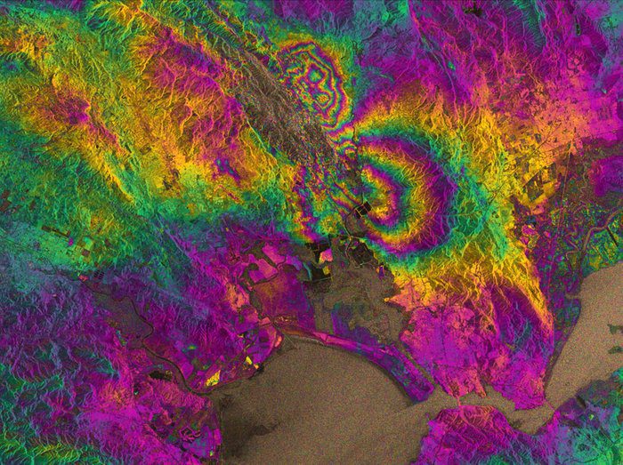
Radar Vision Maps Napa Valley Earthquake
Radar images from the European Space Agency's newly launched Sentinel-1A satellite have been used to map the rupture caused by the largest earthquake to shake northern California in 25 years.
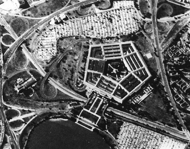
Catching Film in Mid-Air: Revisiting Yesterday's Spy Satellites
Being a U.S. spy satellite in the 1960s wasn't easy”it meant dropping its photos in a special film bucket capsule from space, which the U.S. Air Force then had to catch in mid-air.
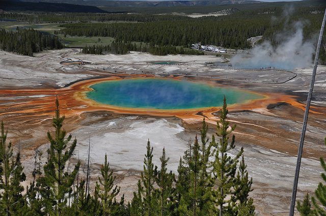
Yellowstone Digs in Its Heels Against Illegal Drones
Yellowstone National Park no longer takes a slap-on-the-wrist approach to people who violate its ban on camera drones. It could result in a $5,000 fine and/or six months in jail.

Recalling Hell with the Lid Off
During the first half of the 20th century, coal-burning power plants, factories and homes produced pollution that likely exceeded modern Beijing, one of the world's most polluted cities.
