Topcon Positioning Group released two unmanned aircraft systems (UASs) for aerial mapping applications: the Sirius Pro and Sirius Basic fixed-wing aircraft systems.
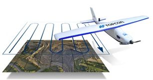
Topcon Positioning Group released two unmanned aircraft systems (UASs) for aerial mapping applications: the Sirius Pro and Sirius Basic fixed-wing aircraft systems.
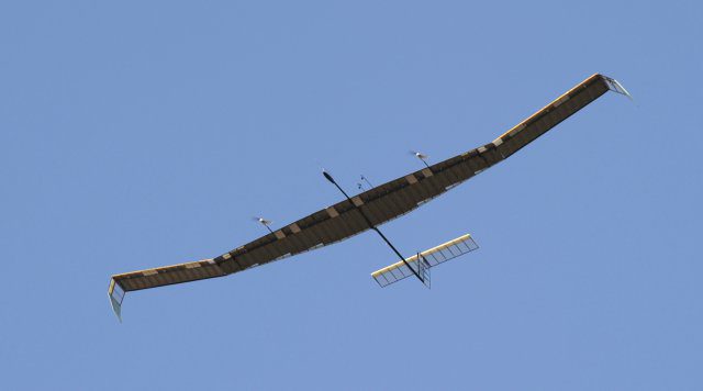
Airbus Defence and Space announced the Zephyr 7 High Altitude Pseudo-Satellite, a type of unmanned aircraft, recently completed its most demanding mission to date.
LONGMONT, Colo., Aug. 26, 2014—DigitalGlobe, Inc. (NYSE: DGI), a leading global provider of high-resolution earth imagery and geospatial solutions, today released the first images from its WorldView-3 super-spectral, high-resolution commercial imaging satellite. The...
DENVER, Sept. 3, 2014—V1 Media welcomes the staff of Earth Imaging Journal (EIJ) as we combine forces to address an Earth observation market that is marked by significant growth prospects and exciting opportunities. The bi-monthly print publication is a great fit...
FORT COLLINS, Colo., Sept. 2, 2014—CartoPac International Inc. today announced a major new release of the CartoPac Mobile Platform. CartoPac 5.0 extends the mobile platform with support for Windows 8 and introduces the CartoPac Workflow Manager, which provides a...
SAN DIEGO, Aug. 26, 2014—With several test flights this summer, the U.S. Air Force RQ-4 Global Hawk Wide Area Surveillance Unmanned Aircraft System (UAS) proved its ability to operate with an expanded variety of intelligence exploitation ground stations and collect...
Colorado Springs, Colo., Sept. 2, 2014—Jason Caldwell has been promoted to Vice President of Business Development and Sales at the Sanborn Map Company, Inc. In his new role, Caldwell will oversee Sanborn’s team of marketing and sales professionals, as well as the...
SEATTLE, Sept. 3, 2014—LizardTech®, a provider of software solutions for managing and distributing geospatial content, launched GeoGofer, a new addition to its product line. GeoGofer is a software solution for finding geospatial imagery quickly and efficiently,...
Aug. 26, 2014—The Open Geospatial Consortium (OGCⓇ) membership seeks public comment on the candidate OGC Web Processing Service (WPS) Version 2.0 Interface Standard. In many cases geospatial or location data, including data from sensors, must be processed before...
Montreal, Canada, Aug. 27, 2014—SimActive Inc., a world-leading developer of photogrammetry software, is pleased to announce Correlator3D™ version 5.3, with significantly faster orthorectification. The process is now powered by GPU technology and multi-core CPUs,...
