Des Plaines, IL, January 5, 2016 — URISA is pleased to announce the Call for Presentations for GIS-Pro 2016: URISA's 54th Annual Conference in Toronto, Ontario. The conference will take place at the Westin Harbour Castle, October 31-November 3, 2016. The GIS-Pro...
VisionMap Announces New Website Launch
Tel Aviv, Israel – January 5, 2016 - VisionMap, a leading provider of automatic airborne imaging systems, announced the launch of its new website www.visionmap.com. The new website provides quick and intuitive access to VisionMap’s versatile line of products and...
XXIII ISPRS Congress – Final Days for Submission!
The deadline for Abstracts is 7th January, 2016. Do not forget to upload your abstract. Use ISPRS template available for download here. Unfortunately, the deadline of submission for Full Papers has expired on 13th December. In case, you have missed the deadline, as...
ESA Funded A-SeNS Enables Port-Log Data to be Captured by Satellites
The Automatic Identification System (AIS) is a tracking system used by ships and vessel traffic services for identifying and locating vessels by electronically exchanging data with other nearby vessels, shore stations and satellites. As well as providing information...
Romanian Surveying Company Selects SuperSurv
With assistance from Helix SRL, Supergeo’s partner in Italy, the Romanian company Black Light SRL has recently selected the well-known mobile GIS software SuperSurv as its mobile geospatial solution. Established in 1992, Black Light SRL is a surveying company with...
New Release of SuperGIS Server 3.2
Supergeo is proud to announce that the latest version of SuperGIS Server 3.2 is now available on our official website. This release includes some new features as well as improvements that make SuperGIS Server even better. For example, users can now publish pre-cached...
Phase One Industrial Announces 100 Megapixel Medium Format Metric Cameras for Aerial Data Acquisition
COPENHAGEN, January 3, 2016 ― Phase One Industrial, a leading developer of aerial medium format camera equipment, today announced 100 MP CMOS-based medium format metric cameras available for aerial mapping and other demanding applications. The development of the...
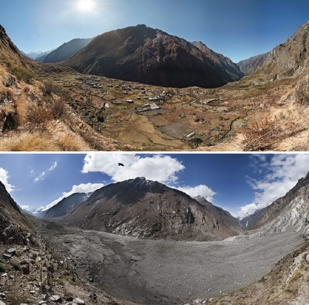
Satellite Imagery Catalogs Nepal Earthquake Landslides
Scientists with the Global Land Ice Measurements from Space (GLIMS) network, an international consortium of glaciologists, used satellite imagery to search for landslides after the April 25, 2015, earthquake that claimed more than 9,000 lives in four countries, primarily Nepal.
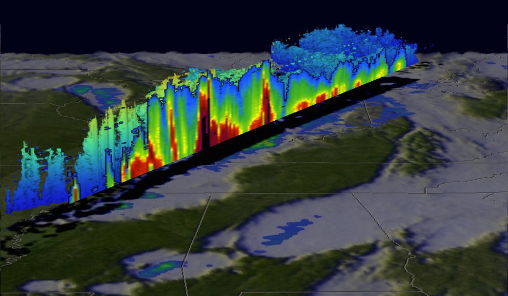
NASA Satellite Tracks Deadly U.S. Weather
The Global Precipitation Measurement (GPM) satellite, an international mission between NASA and the Japan Aerospace Exploration Agency, analyzed extreme weather that affected the United States between Dec. 23-27, 2015.
GeoCue Announces Release of LP360 2015.1
Huntsville, AL – GeoCue Group is pleased to announce the latest release of LP360. Available both as an add-in to ArcGIS® and as a standalone 64 bit application, LP360 is the world’s most powerful and popular LIDAR extension for the ESRI environment. This release...
