CubeSat Maps Global Air Traffic

CubeSat Maps Global Air Traffic

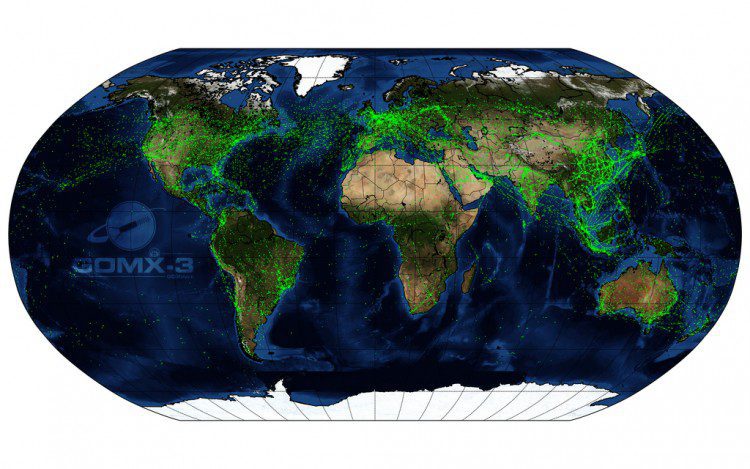
The GomX-3 CubeSat, which was ejected from the International Space Station on Oct. 5, 2015, has been tracking aircraft in flight across Earth. Built for the European Space Agency (ESA) by GomSpace in Denmark, the CubeSat's distinctive helical antenna has detected millions of signals from aircraft.

Mysteries of Wobbling Earth Solved

Mysteries of Wobbling Earth Solved

Using satellite data on how water moves around Earth, NASA scientists solved two mysteries about wobbles in the planet’s rotation. Earth's spin axis drifts slowly around the poles; the farthest away it has wobbled since observations began is 37 feet (12 meters). These wobbles don't affect daily life, but they must be taken into account to get accurate results from GPS, Earth-observing satellites and ground-based observatories.

Teledyne to Acquire CARIS

THOUSAND OAKS, Calif. and Fredericton, NB, Canada  – Teledyne Technologies Incorporated (NYSE:TDY) (“Teledyne”) and CARIS jointly announced today that the CARIS business and its international affiliates (collectively, “CARIS”) have agreed to be acquired by...

Sanborn Observes 150th Anniversary

COLORADO SPRINGS, Colo., April 11, 2016  -- The Sanborn Map Company, Inc. (Sanborn) is well known by its customers as a cutting-edge technology firm, but its rich history often surprises many. Founded in 1866 to produce fire insurance maps, modern-day Sanborn offers...

Basis Software Introduces All New Surphaser Model 10

Basis Software, Inc, is pleased to introduce the Surphaser Model 10 laser scanner, the first in a new product line of compact light weight scanners. The new model will be presented at the SPAR 3D Expo and Conference, Woodlands, Texas. The Surphaser Model 10 represents...

NCTech Unveils New 360 Degree Imaging Developments

Edinburgh, UK and Houston, TX  – NCTech, the developer of reality imaging systems, recently announced two new developments for its industrial-grade iSTAR panoramic camera. The company will be demonstrating these developments at the SPAR 3D conference and tradeshow...

TerraGo Edge Delivers GeoPackage to Mobile Users

TerraGo, a pioneer of geospatial collaboration, field engineering and enterprise mobility software, announces the availability of TerraGo Edge 3.9.3, which features full support for OGC GeoPackage, a universal format for sharing maps and geographic data across mobile...

New Maps for Texas and Oklahoma Released

New US Topo maps for Texas and Oklahoma are now available in the USGS Store for free download. One of the main improvements is the inclusion of the U.S. Census Bureau’s Topologically Integrated Geographic Encoding and Referencing (TIGER) road data. “The US Topo...

NEWEST V1 MEDIA PUBLICATION

April Issue 2024