Lokeren, Belgium — Orbit GT will be launching new UAS Mapping software at the upcoming SPAR event in Houston, USA. “We’re very pleased to announce that our UAS Mapping software is available for purchase and will be launched at SPARâ€, says Peter Bonne, CEO of...
Remote Sensing Industry Expanding Commercial Opportunities, Reports BCC Research
WELLESLEY, MA — The remote sensing community has expanded beyond national space agencies and handful of private companies to include scores of small businesses that specialize in creating customized imagery from free and low-cost government-acquired data. BCC...
GEO Business Launch Hard Hitting Conference Programme Featuring Leading Organisations in the Geospatial Industry
The The highly anticipated and action packed GEO Business Conference Programme has been launched to critical acclaim as it brings together some of the most high profile names within the industry. Presentation and panel debate contributors include, but are not limited...
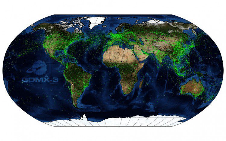
CubeSat Maps Global Air Traffic
The GomX-3 CubeSat, which was ejected from the International Space Station on Oct. 5, 2015, has been tracking aircraft in flight across Earth. Built for the European Space Agency (ESA) by GomSpace in Denmark, the CubeSat's distinctive helical antenna has detected millions of signals from aircraft.
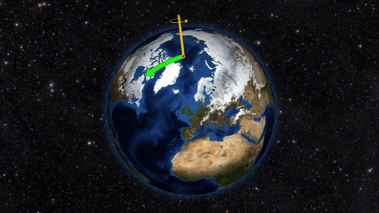
Mysteries of Wobbling Earth Solved
Using satellite data on how water moves around Earth, NASA scientists solved two mysteries about wobbles in the planet’s rotation. Earth's spin axis drifts slowly around the poles; the farthest away it has wobbled since observations began is 37 feet (12 meters). These wobbles don't affect daily life, but they must be taken into account to get accurate results from GPS, Earth-observing satellites and ground-based observatories.
Teledyne to Acquire CARIS
THOUSAND OAKS, Calif. and Fredericton, NB, Canada – Teledyne Technologies Incorporated (NYSE:TDY) (“Teledyneâ€) and CARIS jointly announced today that the CARIS business and its international affiliates (collectively, “CARISâ€) have agreed to be acquired by...
Sanborn Observes 150th Anniversary
COLORADO SPRINGS, Colo., April 11, 2016Â -- The Sanborn Map Company, Inc. (Sanborn) is well known by its customers as a cutting-edge technology firm, but its rich history often surprises many. Founded in 1866 to produce fire insurance maps, modern-day Sanborn offers...
FARO Announces New HDR Laser Scanners and Instant Rendering Software for BIM-CIM and Public Safety Customers
LAKE MARY, Fla., April 11, 2016 — FARO Technologies, Inc. (NASDAQ: FARO), the world's most trusted source for 3D measurement, imaging, and realization technology in the BIM-CIM and Public Safety markets, announces the release of new 3D laser scanners with high...
NOVA IMS First International GEOINT Program to Achieve USGIF Accreditation
Herndon, Virginia (April 11, 2016)—The United States Geospatial Intelligence Foundation (USGIF) is excited to announce the addition of NOVA Information Management School of the Universidade Nova de Lisboa (NOVA IMS), located in Lisbon, Portugal, to its growing list...
Basis Software Introduces All New Surphaser Model 10
Basis Software, Inc, is pleased to introduce the Surphaser Model 10 laser scanner, the first in a new product line of compact light weight scanners. The new model will be presented at the SPAR 3D Expo and Conference, Woodlands, Texas. The Surphaser Model 10 represents...
