Westminster, CO (April 19, 2016) – The MobileMapper 300 smart antenna and DigiTerra Explorer v7, one of Europe’s leading GIS software solutions for mobile mapping, now interface seamlessly. This enables the DigiTerra Explorer to drive the MobileMapper 300...
Boundless Sponsors American Geographical Society's New AGS AP Teachers Fellows Program
Washington D.C — Boundless, the world leader in commercially supported open source GIS software, is proud to announce its sponsorship of the American Geographical Society’s AP Teachers Fellow program. Boundless is providing a grant which will underwrite the...
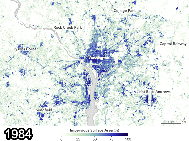
Landsat Data Document Pavement Increase in D.C.
A study recently published in the Remote Sensing of Environment journal used Landsat data from 1984 and 2010 to show how paved surfaces in the Washington, D.C., area have increased dramatically.
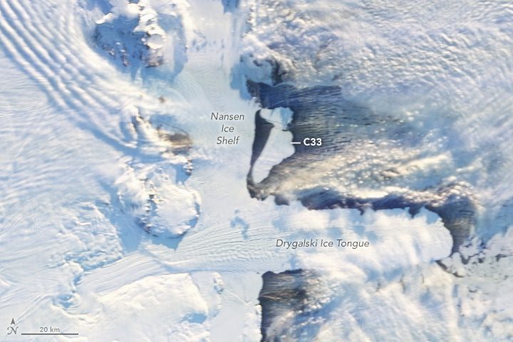
Antarctic Icebergs Break Free
On April 7, 2016, multiple satellites captured the birth of two large icebergs that were shed along a crack on Antarctica's Nansen Ice Shelf during persistent strong offshore winds. The icebergs currently pose no threat to shipping, but they may pose a threat to scientific instruments moored to the seafloor to monitor climate change.
LandWorks, Inc. Partners with USLandGrid
HOUSTON, TEXAS, April 18, 2016 – LandWorks Inc., a developer of innovative land management and related GIS software, announced its reseller partnership with USLandGrid, a provider of high resolution vector data. LandWorks’ core business is providing land...
Emapsite Launches Postcode-Level UK Windstorm Peril Model
Data services provider emapsite has launched a postcode-based perils model enabling insurers and underwriters to assess the windstorm risk to properties in the UK. The windstorm data is available as a discrete data set and through an on-demand data-hub location...
Boundless Named in GovTech 100
Washington D.C  — Boundless, the world leader in commercially supported open source GIS software, has been named on the GovTech 100 Top Innovation Companies Focused on Government. Government Technology and e.Republic Labs put together this list of the “leading...
MapAction Mobilises Humanitarian Mapping Team for Ecuador Earthquake
Saunderton, Bucks, Monday 18th April — Two MapAction volunteers have set off for Ecuador this morning in response to Saturday’s major earthquake. MapAction’s support was requested by the United Nations, following a call for international assistance from the...
Calling All Innovators: Competition Seeks Applications Leveraging Data from Space
Visionary teams and individuals from the realms of business, research, and higher education now have the chance to write their own chapter of the Copernicus Masters success story. Geared towards entrants from all over the world, the sixth edition of the biggest...
Happy 80th Birthday to the Trig Pillar
On 18 April 1936 a group of surveyors gathered around a white concrete pillar in a field in Cold Ashby and began the retriangulation of Great Britain. That trig pillar is still standing 80 years on, along with thousands more around the country. We’re celebrating by...
