IRVINE, Calif., June 1, 2016 – CoreLogic (NYSE: CLGX), a leading global property information, analytics and data-enabled services provider, today released its 2016 Storm Surge Report which concludes that more than 6.8 million homes on the Atlantic and Gulf coasts...
Mapping that Sinking Feeling
For a low-lying, densely populated country like the Netherlands, monitoring subsidence is critical. Until recently, tiny displacements in the ground beneath our feet couldn’t be mapped nationally but, thanks to the Sentinel-1 mission, this is now possible. Focusing...
3D Laser Mapping Launches New Multiplatform Mapping System
World leading geospatial technology supplier, 3D Laser Mapping, has launched an innovative multi-platform mapping system at GeoBusiness 2016. The new platform, named ROBIN, is the first of its kind on the market and provides three alternative mapping options rolled...
Increasing Adoption of Hyperspectral Imaging Boosting Global Market, Reports BCC Research
WELLESLEY, MA, June 01, 2016 - Rising demand for high-bandwidth communication and installation of higher capacity communication networks is growing demand for highly precise hyperspectral imaging. BCC Research anticipates in its new report that the hyperspectral...
The Bureau of Land Management Uses Esri Story Maps to Encourage Public Land Exploration
Redlands, California —The Bureau of Land Management (BLM) now uses Esri Story Maps to encourage exploration of the United States' public land treasures. The story maps document the travels of BLM wilderness specialist and photographer Bob Wick and were designed to...
Esri to Host Imaging and Mapping Forum at Esri User Conference
Redlands, California —Earlier this week, Esri announced the featured speakers at the first Esri Imaging & Mapping Forum, to be held in San Diego, California, June 25–26. Conference speakers will explore innovative technologies that are transforming traditional...
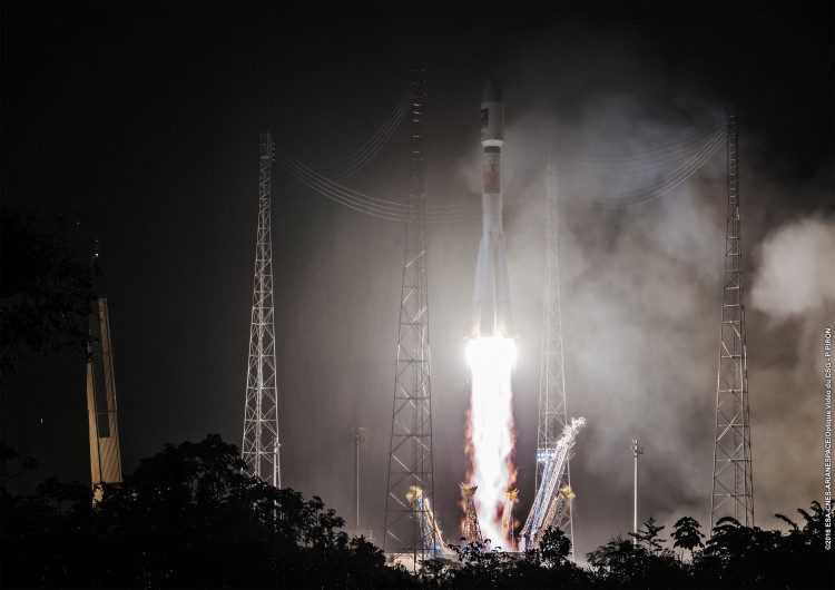
Europe's Galileo Navigation System Adds Two Satellites
The European Union-funded Galileo satellite navigation system added its 13th and 14th satellites after a successful launch atop a Soyuz rocket from French Guiana on May 24, 2016. Nearly four hours after liftoff, the twin Galileos were deployed into orbit approximately 23,522 kilometers above Earth.
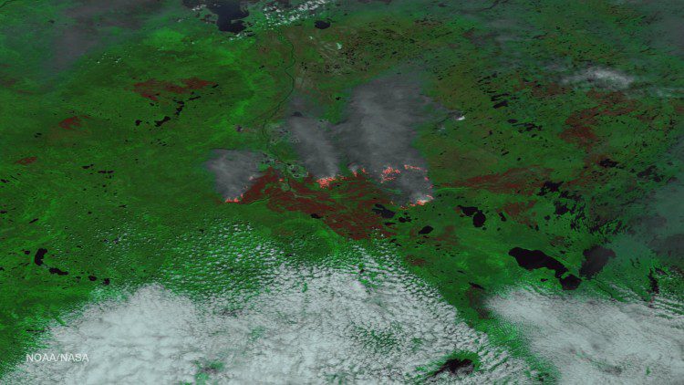
Canada's Fort McMurray Fire Continues to Rage
The Alberta Ministry of Agriculture and Forestry reports that the Fort McMurray wildfire is now estimated to be more than 522,892 hectacres in size (1,292,094 acres”an area larger than the state of Rhode Island).
YellowScan LiDAR for Drone 2016: User Conference will be held June 22-23 in Château Flaugergues, Montpellier, France
YellowScan has put together a diverse and exciting agenda for the YellowScan LiDAR for Drone 2016 User Conference, proving the broad usage of YellowScan LiDAR equipment in applications such as archeology, forestry, powerlines, surveying, mining, civil engineering and...
$26 Billion Remotely Piloted Aircraft Systems Market by 2025
Paris, Washington D.C., Montreal, Yokohama, May 31, 2016Â - According to Euroconsult's latest report, Prospects for Remotely Piloted Aircraft Systems, the size of the professional RPAS (Remotely Piloted Aircraft Systems) manufacturing and services market is expected...
