NORCROSS, GA - Hexagon Geospatial is proud to launch M.App Enterprise. This privately-hosted solution enables organizations to provide and share their own information services that dynamically address their location-based challenges. Hexagon Smart M.Apps are simple to...
Luciad Announces Impressive Speaker Line-Up for its INTERACT User Conference
Belgium, Leuven – 11th August, 2016 - Luciad is delighted to announce several new speakers for INTERACT - The Luciad User Conference 2016. The conference is the premier event for geospatial professionals and developers from the Aviation, Defence, Maritime, Safety...
Esri Observes The United Nations' International Day of the World’s Indigenous People with Tribal Story Map Challenge
Redlands, California —The United Nations’ International Day of the World's Indigenous People is observed each year to promote and protect the rights of the world’s indigenous population. This year’s theme is right to education, and in honor of this, Esri...
iSTAR 360 Degree Measurement Module Integrated by Imaging Companies
Edinburgh, UK – August 10, 2016 – NCTech, the developer of reality imaging systems, today announced that the Measurement Module for its industrial-grade iSTAR panoramic camera has been integrated into offerings from software firms Arithmetica and Veesus. ...
UN-GGIM: Europe Announces Creation of GRF-Europe
Europe is contributing to the UN’s Global Geodetic Reference Frame (GGRF) by developing a platform for exchanging information and expertise.  The creation of a new UN-GGIM: Europe working group, GRF- Europe will connect a range of stakeholders and act as an...
Service Hydrographique et Océanographique de la Marine Chooses Global Mapper for Coastal Mapping Project
Hallowell, Maine – Blue Marble Geographics is pleased to announce that the Service Hydrographique et Océanographique de la Marine (SHOM) has selected Global Mapper for its Litto3D® project. The goal of this ambitious program is to create a seamless,...
Surrey Satellite and NanoRacks Teaming for Deployment of 100-kilogram-class Satellites from the ISS
ENGLEWOOD, COLO. — Seeking to expand the satellite launching capabilities of the International Space Station, Colorado-based Surrey Satellite Technology US LLC (SST-US) has signed a contract with NanoRacks LLC for future flights of a 100-kilogram-class satellite...
SmartNet Expands in Western Canada Through Merger with Pleiades Reference Station Network
Leica Geosystems today announced that SmartNet North America (www.smartnetna.com), the industry-leading high-precision, high-availability network RTK correction service, has merged with the Pleiades reference station network in Western Canada, operated by Pleiades...
INTERGEO TV in August
As the international information platform for the geocommunity, INTERGEO TV is showcasing various topical productions on the news portal www.intergeo-tv.com in August. The August edition of the News (online from 4 August) explores the extent to which geodata and...
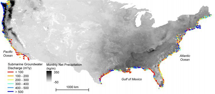
Study Maps Hidden Water Pollution in U.S. Coastal Areas
Coastal waters and nearshore groundwater supplies along more than a fifth of coastlines in the contiguous United States are vulnerable to contamination from previously hidden underground transfers of water between the oceans and land.
