August, 2016 - Washington, DC Â - Â Boundless Exchange 1.0, a GIS content management platform powered by open source technology, is now available. Boundless Exchange enables spatial and mapping capabilities via a modern web platform. Boundless Exchange 1.0 has...
Bluesky Geospatial Expands Into Ireland
Bluesky Geospatial, a U.K. aerial survey company, has expanded into the Republic of Ireland with the launch of its first wholly-owned regional subsidiary. The company will offer a complete sales and marketing function there, servicing the rapidly expanding Irish...
SatCen and Proximus to Speak at Luciad User Conference 2016
BELGIUM, Leuven: Luciad announced further updates to the speaker programme for INTERACT 2016 today. Alexis Letulier, Head of IT at the European Union Satellite Centre (SatCen), has joined the line-up of renowned experts at Luciad’s international geospatial...
New Report on Cities and Drones Released by National League of Cities
WASHINGTON — The National League of Cities (NLC) today announced the release of Cities and Drones, a new report that provides cities with insight on the recently released Federal Aviation Administration (FAA) rules relating to drone operation. The report also...
exactEarth Awarded Small Vessel Tracking Contract with the Government of Ghana
Cambridge, ON – exactEarth Ltd. (TSX: XCT) (the “Companyâ€), announces that it has been selected by the Fisheries Commission (West Africa Regional Fisheries Programme), an agency of the Ministry of Fisheries and Aquaculture Development (MOFAD) of the Government...
NASA to Highlight Opportunities in North Dakota at UAS Summit & Expo
Grand Forks, ND —North Dakota’s role in NASA research aimed at the safe integration of small and large unmanned aircraft systems (UAS) into the national airspace will be discussed during the 10th Annual UAS Summit & Expo Aug. 22-24 at the Alerus Center in...
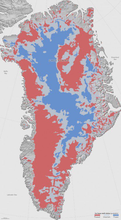
Peeking Under Greenland's Ice Sheet
Greenland's thick ice sheet insulates the bedrock below from the cold temperatures at the surface, so the bottom of the ice often is tens of degrees warmer than at the top.
A Major Upgrade of SuperGIS Network Analyst
SuperGIS Network Analyst is one of the six extensions of SuperGIS Desktop, which is a powerful tool that enables users to conduct network analysis for finding the best route or the most suitable site. Network analysis can be applied in various fields, such as...
IJDE CAll FOR PAPERS: Arctic and High Altitude Mountain Cold Regions: Sustainable Earth Observations and Climate Change
IJDE CAll FOR PAPERS_Arctic and High Altitude Mountain Cold Regions: Sustainable Earth Observations and Climate Change Aim The Artic, Antarctic as well as the Qinghai-Tibet Plateau are typical Earth cold regions where snow and ice dominate the local environment, and...
Call for Papers “ GEOINT Conference at JMU August 2017
James Madison University, in Harrisonburg, Virginia, will host a “Symposium on the Future of Using Geospatial Intelligence to Anticipate Conflict,†August 3-4, 2017 for an audience from academia, business, and government. Symposium organizers are seeking...
