World leading geospatial technology supplier, 3D Laser Mapping, is unveiling an innovative multi-platform mapping system to the African market at the September Geomatics Indaba 2016 in South Africa. Named ROBIN, the platform is the first of its kind on the market and...
DLRG Uses Drone to Safe Lifes
The world's first drone for daily use is now being used in rescue missions. Phillip Strauch and Thomas Hebestreit recently handed over the first MULTIROTOR G4 drone to Christoph Niemann, the deputy chairman of Germany's largest DLRG base in Scharbeutz. “Deployment...
East View Geospatial Introduces New Image Analysis Services
MINNEAPOLIS - East View Geospatial is pleased to announce the launch of new image analysis services designed to complement the company's ever-expanding sources of satellite data and remote-sensing information. In creating the pioneering new services, East View...
Dewberry Selected to Provide Mapping Services in Southern California
Dewberry has been pre-qualified to provide mapping services in support of several projects for the Metropolitan Water District of Southern California (MWD). Dewberry will serve as a subconsultant to Psomas for projects that may be completed under the on-call,...
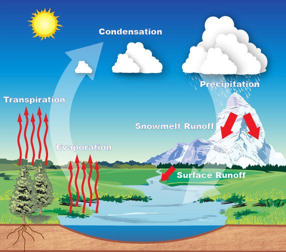
Esri Maps NOAA's National Water Model
Smart-mapping leader Esri today released a beautiful, robust new collection of Web maps that forecast NOAA stream-flow data throughout the continental U.S.
TripAdvisor Acquires Citymaps in Quest to Offer Best-In-Class Tourism Mapping Features for Travelers
NEEDHAM, Mass., Aug. 24, 2016 - Travel planning and booking site TripAdvisor® (www.tripadvisor.com) today announced that it has acquired New York-based Citymaps (https://citymaps.com/), a social mapping platform that enables tourists to discover countless hidden gems...
Euroconsult Takes Majority Stake in SATConsult
Euroconsult today announced that it has taken a majority stake in Southern Aerospace & Telecom Consulting (SATConsult), an independent consulting company based in Toulouse FOCused on supporting the development of Satellite infrastructure worldwide. Under the terms...
Geospatial Corporation Announces New Video Series Highlighting GeoUnderground, Our Cloud-Based GIS Platform
PITTSBURGH -Â (OTCQB:Â GSPH), Geospatial Corporation, a Google for Work Technology Partner today announced a new series of videos highlighting GeoUnderground our cloud-based GIS platform. View videos here. "Geospatial continues to make substantive progress applying...
Open-Source Mapping Company Mapbox Acquires Passive Fitness App-Maker Human for its Anonymized Data
San Francisco-based Mapbox, an open-source mapping platform, has acquired fitness-tracking app Human, which allows users to track activity all day and aggregates the data anonymously to create information about cities. Human is a passive app with a simple goal: move...
TerraGo Magic Unlocks the Secrets to Zero-Code Enterprise Apps
TerraGo, a pioneer of geospatial collaboration, field data collection and enterprise mobility software, announces the availability of TerraGo Magic, a zero-code app platform. With TerraGo Magic, organizations can rapidly deploy iOS, Android and web apps, customized...
