RALEIGH, N.C. - PrecisionHawk Inc. – a leading provider of aerial data and safety platforms for drones – today announced the launch of its low altitude traffic and airspace safety platform (LATAS). LATAS is the only platform to link drones, 3d ground data and...
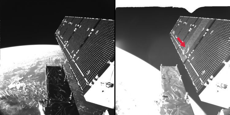
Sentinel Satellite Hit by Space Particle
ESA engineers discovered that a solar panel on the Copernicus Sentinel-1A remote-sensing satellite was hit by a millimeter-sized particle on Aug. 23, 2016.
Timmons Group Redesigns and Implements New Find Wildlife VA Application
The Virginia Department of Game and Inland Fisheries (VDGIF) recently partnered with Timmons Group to redesign and implement the new “Find Wildlife VA†application. VDGIF has distinct users, such as hunters, wildlife viewers, anglers, and boaters that require...
All New KODAK PIXPRO SP360 4K Aerial Pack With Made For SOLO 3DR Drone Mount Ships
LAS VEGAS —   InterDrone 2016 – Paris Hotel, Booth #603 -- JK Imaging Ltd., the worldwide licensee for KODAK PIXPRO Digital Cameras and Devices, today announced its highly anticipated US availability of another groundbreaking and new SP360 4K accessory pack,...
PRODRONE Unveils the World’s First Dual Robot Arm Large-Format Drone
NAGOYA, Japan — Prodrone Co., Ltd. is pleased to announce it has developed the PD6B-AW-ARM, a large-format drone equipped with two internally-developed robotic arms, enabling it to directly accomplish a variety of tasks. PRODRONE will showcase the new model at its...
TomTom Announces TomTom BRIDGE Connected for Fleets
LAS VEGAS - TomTom, Inc. a global leader in navigation and mapping products, today announces TomTom BRIDGE Connected, with a built-in modem for wireless functionality. Wireless connectivity allows drivers to directly connect with their customers, get updates as they...
Develop IoT Visualizations Faster and Easier with the Release of SensorThings Highchart and DataTable
Calgary, A.B. – Geospatial Internet of Things (IoT) leader SensorUp announced the release of the SensorThings Highchart and DataTable (SensorThings HcDT). SensorThings HcDT is a javascript-based visualization Software Development Kit (SDK) built specifically for...
AirMap And PASSUR Aerospace, Inc. Announce Exclusive Agreement to Integrate PASSUR's Live Flight Data With Airmap's Airspace Management Platform “ Real-Time Traffic Alerts Enhance Situational Awareness in Low-Altitude Airspace for Drones and Manned Aircraft
STAMFORD, CT and SANTA MONICA, CA – AirMap, the leading airspace management platform for drones, and PASSUR Aerospace, Inc, (OTC: PSSR), the leading air traffic management platform for manned aviation, announced today that they have partnered to integrate...
PRODRONE Develops a Self-Propelling Surface-Clinging Drone Able to Inspect Both Ceilings and Vertical Walls
PRODRONE Develops a Self-Propelling Surface-Clinging Drone Able to Inspect Both Ceilings and Vertical Walls | Business Wire NAGOYA, Japan--(BUSINESS WIRE)--Prodrone Co., Ltd. is proud to announce it has developed the PD6-CI-L, a self-propelling surface-clinging drone...
Esri, Audubon Society, Echosec, and Mapillary Take Home Gold and Silver Medals at the Stevie International Business Awards
REDLANDS, Calif.- Global smart-mapping leader Esri and three of its customers were recognized at the 13th Annual International Business Awards (IBA) for exemplary achievement in the workplace. The International Business Awards, known as the Stevies, is one of the best...
